Sao Francisco do Sul
| Sao Francisco do Sul | |
|---|---|
|
Coordinates: 26 ° 15 ′ S , 48 ° 38 ′ W
Sao Francisco do Sul on the map of Santa Catarina
|
|
| Basic data | |
| Country | Brazil |
| State | Santa Catarina |
| City foundation | January 5, 1504 (discovery), 1658 (foundation) |
| Residents | 42,569 (IBGE 2010) |
| City insignia | |
| Detailed data | |
| surface | 540 km 2 |
| Population density | 79 people / km 2 |
| Waters | Baía da Babitonga, South Atlantic |
| Post Code | 89240-000 |
| prefix | 47 |
| Time zone | UTC −3 |
| City Presidency | Luiz Zera ( PP ) |
| Website | |
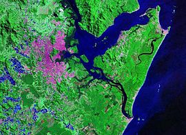
| Satellite image with the Baía de Babitonga (center), Joinville (left) and the Ilha São Francisco do Sul (right). | |
São Francisco do Sul is the third oldest inhabited settlement after the discovery of Brazil in 1500. It is located in the north of the state of Santa Catarina , in the north of the island of Ilha de São Francisco do Sul. It was founded in 1504 , but only became independent in 1660 and became a town after 1847 . In 2010, 42,569 inhabitants lived here on a total area of 540 km². It is located on the Atlantic bay Baía da Babitonga at an altitude of 1-9 m above sea level.
Economy and port
São Francisco do Sul has the fifth largest container port in Brazil and, along with the ports of Itajaí and Rio Grande, is the most important in southern Brazil. 70% of the town's income is generated here. The port is located on the island of Ilha de São Francisco do Sul, approx. 45 km from Joinville , 60 km from Jaraguá do Sul and 160 km from Blumenau . The port, together with Itajaí, is considered the main port of the state of Santa Catarina . It supplies the above-mentioned places with goods and the local textile and shoe industry ships large parts of the export cargo here. The draft of the access channel is 14 meters.
In 2010 a total of 726 ships were handled at five berths. The cargo throughput in the same period was 9.6 million tons. The port operations are partly carried out by private companies. However, the administration of the port lies with the Administração do Porto de São Francisco do Sul . In addition to container loading, agricultural bulk goods with appropriate silos also play a role in port handling.
tourism
Portuguese immigrants, mainly from the Azores , built this place, which with its 150 historic buildings has been placed under a preservation order. Despite the busy harbor, the city has retained the character of a romantic place that stretches quietly along the banks of Babitonga Bay. When the French navigator Binot Paulmier de Gonneville anchored in the region in 1504 , this marked the establishment of the oldest settlement of Santa Catarinas. There are a total of 13 beaches in their area, all of them on the nearby Atlantic Ocean. From the fortress Marechal Luz, which is located on a hill above the city, you have a panoramic view of the island of Paz and the bay. The building was erected in 1909 on the ruins of the old Portuguese fortress. Around 100,000 tourists visit the city in summer.
Personalities
- Júlia Maria da Costa (1844–1911), poet, died here
- Carlos Alberto Breis Pereira (* 1965), Catholic clergyman, Bishop of Juazeiro, born here
Individual evidence
- ↑ http://www.suedbrasilien.com/page.asp?id=%7B789D4B21-7BFA-48AD-8514-6300FAD0E35B%7D
- ↑ http://www.sfs.com.br/index.cfm?go=jornal.integra&codNews=6481&codCategoria=11
- ↑ http://www.brasilienportal.ch/brasilien/sueden/santa-catarina/straende-auf-dem-festland/sao-francisco-do-sul/


