Sao Paulo do Potengi
| Município de São Paulo do Potengi SPP
Sao Paulo do Potengi
|
||
|---|---|---|
|
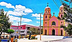
Monsenhor Expedito square with the main church
|
||
|
|
||
| Coordinates | 5 ° 54 ′ S , 35 ° 46 ′ W | |
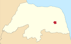
 Location of the municipality in the state of Rio Grande do Norte Location of the municipality in the state of Rio Grande do Norte
|
||
| Symbols | ||
|
||
| founding | December 30, 1943 City charter (age 76) | |
| Basic data | ||
| Country | Brazil | |
| State | Rio Grande do Norte | |
| ISO 3166-2 | BR-RN | |
| height | 91 m | |
| Waters | Campo Grande dam | |
| climate | semiarid, Bsh | |
| surface | 240.4 km² | |
| Residents | 15,843 (2010) | |
| density | 65.9 Ew. / km² | |
| estimate | 17,579 (July 1, 2019) | |
| Parish code | IBGE : 2412609 | |
| Post Code | 59.460-000 | |
| Telephone code | (+55) 84 | |
| Time zone | UTC −3 | |
| Website | prefeituraspp (Brazilian Portuguese) | |
| politics | ||
| City Prefect | José Leonardo Cassimiro de Araújo (2017-2020) | |
| Political party | Psd | |
| Culture | ||
| Patron saint | Paul of Tarsus | |
| economy | ||
| GDP | 162,660 thousand R $ 9257 R $ per person (2017) |
|
| HDI | 0.622 (medium) (2010) | |
São Paulo do Potengi , officially Portuguese Município de São Paulo do Potengi , is a municipality in the Brazilian state of Rio Grande do Norte and is located in the northeast region of Brazil. As of July 1, 2019, the population was estimated at 17,579 inhabitants, who live on a community area of around 240.4 km² and are called Potengienser ( potengienses ). The distance to the capital Natal is 71 km.
geography
Surrounding places are São Pedro , Santa Maria , Barcelona , Lagoa de Velhos , Senador Elói de Souza and Riachuelo . The state road RN-120 leads past the eastern edge of the city . To the west is the Campo Grande dam (Barragem Campo Grande). The municipality is located in a depression between the coastal plateau and the Borborema plateau and has heights of 50 to 200 meters, in urban areas between 72 and 91 meters.
The predominant biome is caatinga .
climate
The community has a semi-arid steppe climate BSh according to the Köppen and Geiger climate classification . The average temperature is 25.5 ° C. The average rainfall is 613 mm per year.
Population development
| year | Residents | city | country |
|---|---|---|---|
| 1950 | 24.192 | 1,358 | 22,834 |
| 1960 | 30.106 | 2,197 | 27,909 |
| 1970 | 12,823 | 3,959 | 8,864 |
| 1980 | 13,553 | 5,581 | 7,972 |
| 1991 | 14,559 | 8,304 | 6,255 |
| 2000 | 13,822 | 9,899 | 3,923 |
| 2010 | 15,866 | 11,490 | 4,376 |
| 2019 | 17,579 | ? | ? |
 |
|||
Source: IBGE (2011)
In 1995 the Distrito de Santa Maria was spun off as an independent municipality of Santa Maria with a large loss of territory for São Paulo do Potengi. The rural population decreased by 12.4% between 1991 and 2010, the last census, and the urban population also increased.
Ethnic composition
Ethnic groups according to the statistical classification of the IBGE (status 2000 with 13,822 inhabitants, status 2010 with 15,866 inhabitants): Of these, 11,468 inhabitants lived in urban areas in 2010 and 4375 in rural areas of the Caatinga. The Sertanejo dialect is spoken in the municipality .
| group | Share 2000 |
Share 2010 |
annotation |
|---|---|---|---|
| Brancos | 4,988 | 5,721 | Whites, descendants of Europeans |
| Pardos | 8,152 | 9,328 | Mixed races, mulattos , mestizos |
| Pretus | 592 | 751 | black |
| Amarelos | - | 31 | Asians |
| Indigenous people | 5 | 12 | indigenous population |
| without specification | 85 | - |
Illiteracy rate
São Paulo do Potengi had an illiteracy rate of 54% in 1991 , which had already fallen to 32.2% in the 2010 census.
| Illiteracy rate | ||||
|---|---|---|---|---|
| year | percent | |||
| 1991 | 54.01 | |||
| 2000 | 42.30 | |||
| 2010 | 32.24 | |||
literature
- Aluísio de Azevedo: História de São Paulo do Potengi. Fundação José Augusto, Natal 1983.
Web links
- City Prefecture website , Prefeitura Municipal (Brazilian Portuguese)
- Atlas do Desenvolvimento Humano do Brasil: São Paulo do Potengi (RN) (Portuguese)
Individual evidence
- ↑ a b c São Paulo do Potengi - Panorama. IBGE , accessed July 9, 2020 (Brazilian Portuguese).
- Jump up ↑ São Paulo do Potengi weather, average temperature, weather forecast. In: de.climate-data.org. Retrieved July 9, 2020 .
- ↑ Evolução da divisão territorial do Brasil 1872-2010 (= IBGE [Ed.]: Documentos para disseminação. Memória institucional . No. 17 ). 2011, ISBN 978-85-240-4208-9 , ISSN 0103-6459 , Evolução da população, segundo os municípios - 1872/2010, p. 230 (Brazilian Portuguese, ibge.gov.br [PDF; 122.3 MB ; accessed on July 9, 2020]).
- ↑ Josiel de Alencar Guedes, Francisca Wigna da Silva Freitas: Cartografia do Desmembramento de Municípios no Estado do Rio Grande do Norte (1980-2000) . In: Revista Geotemas . tape 9 , no. 3 , 2019, ISSN 2236-255X , p. 23–40, here pp. 28, 35 ( academia.edu ).
- ↑ IBGE : Sistema IBGE de Recuperação Automática - SIDRA: Tabela 2093. Retrieved on July 9, 2020 (Portuguese, database query, search terms São Paulo do Potengi (RN) and Cor ou raça).
- ^ Atlas do Desenvolvimento Humano do Brasil: São Paulo do Potengi . Retrieved July 9, 2020 (Portuguese).


