
Southeast Quarter (St. Gallen)
| Southeast quarter | |
|---|---|
| State : |
|
| Canton : |
|
| Constituency : | St. Gallen |
| Political community : | St. Gallen |
| Postal code : | 9000 |
| former BFS no. : | 3203026 |
| Coordinates : | 746 785 / 254 545 |
| map | |
 |
|


The southeast quarter is a district of the city of St. Gallen in the canton of St. Gallen in Switzerland . The most important historical part of the quarter is the Linsebühl. In the district portraits of the city of St. Gallen, it is referred to as a “diverse, underrated district with simple to upscale housing options, with beautiful cafés and restaurants as well as many commercial establishments, with important schools, with city and puppet theater as well as museums, with city park and aviary established retirement centers and hospitals ».
Geography and traffic
The south-east district borders on the St. Gallen old town in the west, the St. Fiden -Quartier in the east, St. Georgen and the Drei Weieren in the south, and the north-east district (St. Jakob) in the north. In the urban subdivision, it includes the statistical quarters Linsebühl and Drei Weieren, whereby the latter is perceived by the city dwellers as part of St. George and is not dealt with further here.
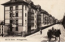
The quarter is roughly divided into two areas. The older one in the valley area of the former Steinach Valley , which led from the Oberer Graben of the former city fortifications north-east along the Lämmlisbrunnenstrasse and Steinachstrasse to St. Fiden, and the younger one on the slope below the Drei Weieren, known as the Dreilindenhang . This was only built after the construction of Wildeggstrasse, which was laid out between 1887 and 1889 as an unemployment project. In addition to residential and commercial areas, the lower part of the quarter also includes the so-called St. Gallen Museum Quarter. The Steinach, which - albeit overcrowded - ran along the Lämmlisbrunnenstrasse and Steinachstrasse through the district until 1991, has since been led through a tunnel under the Dreilindenhang to the so-called Galgentobel in the Heiligkreuz district .
Two important traffic arteries lead through the quarter, the Rorschacherstrasse in the direction of Mörschwil , Goldach and Rorschach and the Speicherstrasse in the direction of Speicher and Trogen in Appenzell Ausserrhoden . Public transport connects the quarter with the bus routes 7, 8 and 11 , the trolleybus routes 1 and 2 , the Trogenerbahn and on Roschacherstrasse with various post bus courses .
population
According to the Statistical Office of the Canton of St. Gallen, 4647 people lived in the Linsebühl-Dreilinden statistical quarter in April 2014. The proportion of Swiss (72%) and EU / EFTA citizens (19%) was 2% higher than the urban average, while at 4% from the rest of Europe, only half as many from these countries lived there. Children and young people lived there with only 11%, a third less than in the rest of the city (17%) with correspondingly more working people and pensioners.
schools
There are no municipal schools in the neighborhood. Municipal educational institutions are only available in the form of 3 kindergartens. The two on Flora- and Konkordiastrasse are organizationally affiliated with the Spelterini school building in the north-east quarter, the kindergarten on Dreilindenhang with the Grossacker primary school building. The only regular school in the district is the canton school on Burggraben . There is also a special education school for children with multiple disabilities in the so-called schoolhouse , which is run by the non-profit and aid society of the city of St. Gallen.
Important buildings and public facilities
The south-east quarter has a large number of public buildings, cultural facilities and infrastructure facilities:
- Historical and Ethnological Museum St. Gallen
- Art Museum St. Gallen
- Theater St. Gallen
- Linsebühl Church (reformed)
- Puppet Theater St. Gallen
- City Park St. Gallen
- Volksbad St. Gallen
- Cantonal school at Burggraben
- Citizens' Hospital (retirement and nursing home) and geriatric clinic
- Schoolhouse (special education school)
- City saw St. Gallen
- Depot of the St. Gallen transport company
- Former Hotel Ekkehard
History and perception
The eastern border of the southeast quarter largely corresponds to the city border to the municipality of Tablat before the city merger in 1918. This also explains why important St. Gallen facilities such as the Bürgerspital (1845), the art museum (1877), the canton school on Burggraben (1856) and the public baths (1906) were built here before 1918. This also explains the Protestant church in Linsebühl, which was built here from 1895 to 1897 as a replacement for the old church from the 15th century and was one of the few early Protestant churches outside the old town, as the surrounding area was predominantly Catholic.

According to an illustration from the 17th century, the Linsebühl (whose name is derived from the Linsenäcker located there) also had an infirmary near the old church, which was near the old church.
Representations from the 19th century with the open and stinking Steinach on Lämmlisbrunnenstrasse make it clear that it was mainly people with low privileges who lived here. The old city maps from the early 19th century show that this area was built on earlier than most other urban areas outside the former city fortifications. The first slaughterhouse in St. Gallen outside the old city walls was also built on the open Steinach in 1858–1860. This was the first independently operated institution to be set up by the political community and was replaced by the slaughterhouse on Schellenacker in 1895 and broken up in 1904.
The compact architecture still suggests today that the Linsebühl was not a respectable quarter and accordingly " establishments " that were to shape the image of the quarter were settled here directly in front of the old town and accessible from the arteries .
In the 20th century, the Linsebühl became more and more a red-light district , whose reputation was known far beyond the city, before an upswing set in in the 2000s and an urban lifestyle established itself instead of the red-light millieu, which according to a radio report for St. Gallen should be atypical.

Web links
Individual evidence
- ↑ Brief portraits of the 18 quarters of the city of St.Gallen. Office for Social Issues, Neighborhood Work, May 21, 2015, pp. 70–71 , accessed on September 26, 2017 .
- ↑ Brief portraits of the 18 quarters of the city of St.Gallen. Office for Social Issues, Neighborhood Work, May 21, 2015, p. 69 , accessed on September 26, 2017 .
- ↑ St. Gallen School Authority: Kindergarten List 2017/18. 2017, Retrieved September 25, 2017 .
- ↑ St. Galler Tagblatt AG, Switzerland: An empty hotel box in a prime location . In: St.Galler Tagblatt . ( tagblatt.ch [accessed September 25, 2017]).
- ↑ City archive of the local citizens' community of St.Gallen. Retrieved September 22, 2017 .
- ^ Hans Stricker: Our city of St. Gallen . Ed .: School administration of the city of St. Gallen. 1st edition. St. Gallen 1970, p. 296 .
- ↑ City archive of the local citizens' community of St.Gallen. Retrieved September 22, 2017 .
- ↑ Digital city map. Retrieved September 22, 2017 .
- ↑ Maria Hufenus: DATA ON THE BUILDING HISTORY OF THE CITY OF ST.GALLEN FROM THE BEGINNING TO 2000. City Archives St. Gallen, 2004, pp. 18, 30 , accessed on October 4, 2017 .
- ↑ aldka: From the red light district for large urban district with flair . In: Swiss Radio and Television (SRF) . ( srf.ch [accessed on September 22, 2017]).