St. Georgen (St. Gallen)
| St. Georgen | |
|---|---|
| State : |
|
| Canton : |
|
| Constituency : | St. Gallen |
| Political community : | St. Gallen |
| Postal code : | 9011 |
| former BFS no. : | 3203035 |
| Coordinates : | 746 595 / 253739 |
| map | |
St. Georgen is a quarter of the Swiss city of St. Gallen .
location
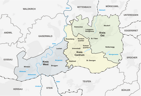
St. Georgen is located in the south of the city, in the Steinach valley , and is connected by bus line 6 . The quarter begins at the upper end of the Mulenenschlucht and extends to the end of the village above St. Georgen-Bach along the creek. In addition, you can reach the quarter with the Mühleggbahn from the city center. In April 2014, 5201 people lived in the quarter, with 16% foreigners, which is below the average of 30% for the entire city of St. Gallen and is the second lowest in the city.
Townscape
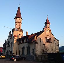
At the western end of St. Georgen, in the “Valley of Humility”, is the shooting range of the St. Gallen Field Rifle Society. The Schützenhaus Weierweid was built on the occasion of the Federal Rifle Festival from July 16 to 28, 1904, it is still used for shooting events and the “ mandatory shooting ” and has facilities for 300 m, 50 m, 25 m and a 10 m -Air pressure system. The building, built in the local style, belongs to the inventory of buildings worthy of protection of the city of St. Gallen, while the whole of St. Georgen is listed in the inventory of places worth protecting ISOS as a place of national importance. The rows of houses on Gellertstrasse and Hebelstrasse, which were built during the heyday of St. Gallen embroidery from 1903 to 1911, are also influenced by the Heimat style. In 2019, a renaturation project began in the valley of humility at the western end of the quarter, in which the overturned Weierweidbach, which flows in the direction of Riethüsli , is exposed, renatured and upgraded with a path.
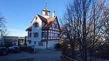
Another noteworthy building in St. Georgen that has a historical background is the “Falkenburg” restaurant. The original version of the building was built in 1497 by the city citizen Heinrich Hochreutiner on the Bernegg slope, and changed hands several times until 1660, when it was bought by the city and from then on served the ruling mayor as a summer residence. After the fall of the city republic, the property was sold again in 1808 and a restaurant opened in it in 1861, which was given the name that is still used today. The restaurant is now owned by the local community of St. Gallen, which acts as the lessor, and is housed in a modern annex. A fire broke out in the historic building on January 28, 2017, causing great damage. The adjoining restaurant was spared. As part of the renovation in cooperation with the monument protection, a mini hotel with 4 rooms, 7 beds and a seminar room was set up in the old building and opened in spring 2019.
The Benedictine convent of St. Wiborada also existed in St. Georgen for centuries . The St. Georgen seminar is located in its place today. In the garden of the former monastery, women from the local association are also in the process of bringing the monastery garden back to life.
Geographical features
The following description of the geography of St. George is based on the area that is defined for St. Georgen in the publication on district portraits by the Office for Social Issues of the City of St. Gallen and is perceived as such by the residents. In terms of the neighborhood groups and the statistical neighborhoods, the Drei Weieren would belong, for example, to the Southeast Quarter and Birt and Less Pond to the Notkersegg Quarter .
Most of the settlement area of St. Georgen lies in the Steinach valley and is separated from the rest of the city on the north side by the range of hills of Freudenberg (887 m) and Kapf (933 m). The hill range itself is characterized on both sides by farms and the municipal forest of the city, but has been built more and more densely on its south side in recent years. In 2015 it was decided to build a new road in order to develop the last building land reserves in the district. Since the rest of the undeveloped area of the quarter is agricultural and green zones, the rural character is likely to be preserved and thus remains a recreational area almost enclosed by the urban settlement area. Up until the mid-1950s there was even a restaurant on the Freudenberg, which was burned down by the civil defense in 1956 after the 1952 plan to build a cable car from the city to the mountain had failed. Only a chestnut avenue on the footpath and old foundation walls on the top of the hill are evidence of the restaurant.
The highest point in the city of St. Gallen is also in St. Georgen, "im Birt" on the Eggen range of hills at 1074 m. There is also one of the three ski lifts in the city of St. Gallen (the valley station of which is in the canton of Appenzell Ausserrhoden), and a second is also in St. Georgen on the "Beckenhalde", directly opposite the Weierweid Schützenhaus on its target slope.
At the upper end of the Steinach valley lies the “ Less Weier ”, which was built by the entrepreneur Michael Less in 1821–1823 to help the industrial companies that were located in St. Georgen, but also in the city of St. Gallen, through the dry season To be able to supply water to the stream or via pipes. The area around the pond has been a nature reserve of partly national importance since 1979 and borders directly on St. Georgen. Since 2011, a “natural and industrial path” created by the Natural Science Society of St. Gallen NWG has led from the “Less pond” through the “Philosophental” upper Steinach Valley, St. Georgen and the Mühlenenschlucht to the valley station of the Mühleggbahn.
St. Georgen had another artificial body of water: the "Rütiweiher" was located on the slope of the Eggenhöhenzug south of the Steinach and was filled up in 1836. Like the "Less pond", the "Rüti pond" also served to ensure the water supply for the industrial plants in St. Georgen and the Mühlenenschlucht when the water level in the Steinach was low. The reservoirs performed another important service as retention basins during floods during storms and when the snow melts. Violent flood events from the years 1478, 1552 and 1774 are known from old chronicles, which swept away entire stables and cattle and claimed human lives.
At the latest with the nationwide electrification, the pond lost its importance as an industrial waterfront, was sold in 1966 and converted to a fishing water. At the beginning of the 1990s, as a result of the new dam regulation, it had to be opened and the water drained. It was given to the city of St. Gallen. Due to the fact that the "Rütibach" can now flow freely again, floods with severe building damage occurred in St. Georgen in 2002 and 2005, which is why the city council decided to build a retention basin at the site of the former pond. Since the dam wall was built as an earth wall because of its location in a protected area and not enough building material could be found, its completion was delayed. The construction of the wall was completed at the end of 2017 and the last measuring and alarm systems were completed in mid-2018.
The Drei Weieren, a destination for excursions and recreation in St. Gallen, are also located in St. Georgen.
Industrial history
Several important companies in Swiss industrial history had their origins in the Steinach Valley because of the easy access to water power. The Winterthur entrepreneur Johann Jacob Rieter founded a spinning mill in 1810/1811 together with Michael Less, which was converted into a chocolate factory in 1884 and is one of the first industrial companies to use the hydropower of the Steinach. Michael Less also founded the machine shop and foundry in which Franz Saurer worked before he founded his own foundry , also on St. Georgenstrasse. After the death of Less, the factory was taken over by the Augsburg financier and entrepreneur Gottlieb Baron von Süsskind and continued to be run by his heirs until it was liquidated in 1910/1912. Part of the assembly hall is still on St. Georgenstrasse today and serves as a storage hall for buses in the basement and houses a full-day school on the upper floor.
After most of the factories had moved away, the last industrial operation was the chocolate manufacturer Maestrani in St. Georgen, which produced chocolate there between 1884 and 2003 until the company moved to Flawil . In front of the chocolate factory, the spinning mill founded by Less and Rieter had been in the buildings. A residential complex including a kindergarten was built on the “Schokoladenweg” in place of the factory building.
schools
St. Georgen has two primary school buildings (“Hebel” school building and “Bach” school building) and five kindergartens. The proportion of foreign language students in these school buildings (and in the Rotmonten school building ) is low compared to the rest of the city, making them popular educational institutions for wealthier parents. This topic is discussed in the city under the catchphrase “mountain and valley school houses” because these school houses are located in the higher-lying quarters of St. Georgen and Rotmonten.
The lever school was inaugurated in 1904 and expanded in 1921/22. Like the houses on the adjacent Hebelstrasse and Gellertstrasse, it is influenced by the Heimatstil and forms an architectural unit with them.
The Bach schoolhouse was built in the Tablat community, which was under the prince abbot until 1798, between the years 1881 and 1885 by the Tablat Evangelical School Community, founded in 1852/62. This is because the industrialization caused both the total population of St. Georgia and the proportion of Protestant people to rise sharply. The Catholic and Reformed school communities remained separate until Tablat was annexed to the city of St. Gallen in 1918.
As of 2018, the Hebelschulhaus should have been refurbished due to the expected sharp increase in the number of pupils, with a new spatial concept creating additional classrooms. This was after earlier expansion plans were suspended due to changing statistical forecasts. The plan to expand the attic of the building, which was planned in 2014, was dropped. However, the project was postponed further and in 2018 a temporary day care facility was set up in the schoolyard, in which additional classrooms will also be accommodated. The renovation should now be completed by the school year 2022/23, including a neighboring residential building. At around the same time (summer 2023) the day care, the winning project of which was selected in 2019, is to be completed
Currently (2019) there are 5 kindergarten classes, 5 basic level classes (1st / 2nd grade) and in the intermediate level 2 3rd, 4th, 5th and 6th grades and a 5/6. Together with over 350 students. 17 classes are expected by 2022/23.
For further education after the intermediate level (4th to 6th grade), the students have to attend schools in other quarters.
Web links
Individual evidence
- ↑ According to the Department for Statistics, Canton St. Gallen.
- ^ Office for Social Issues , City of St. Gallen: Brief portraits of the 18 quarters of the City of St. Gallen. May 21, 2015, pp. 57–58 , accessed November 10, 2016 .
- ^ Feldschützen-Gesellschaft - Feldschützen-Gesellschaft of the city of St. Gallen. In: www.feldsg.ch. Retrieved November 9, 2016 .
- ↑ St. Gallen city map Internet version. In: stadtplan.stadt.sg.ch. Retrieved November 9, 2016 .
- ↑ Site map inventory sheet St. Gallen-St. George. Canton of St. Gallen, accessed on November 9, 2016 .
- ↑ Natural Science Society of St. Gallen: Tafeln Industrie- und Naturweg. P. 24 , accessed on November 9, 2016 .
- ^ Renaturation of Weierweidbach and revaluation of the valley of humility. Retrieved September 12, 2019 .
- ↑ Ernst Ziegler, St. Galler Tagblatt: Das uber der Stadt. In: St. Galler Tagblatt. May 27, 2000, archived from the original on February 23, 2017 ; accessed on February 22, 2017 .
- ^ St. Gallen: Falkenburg host: "The flames were too big for the fire extinguisher". Retrieved May 20, 2019 .
- ↑ Seraina Hess: Falkenburg St.Gallen: Soon the first guests will be sleeping in the mini hotel. Retrieved May 20, 2019 .
- ^ Wiborada garden women. Retrieved November 3, 2017 .
- ↑ Brief portraits of the 18 quarters of the city of St.Gallen. Office for Social Issues, 9004 St. Gallen, May 21, 2015, p. 7 , accessed on July 6, 2017 .
- ↑ St. Galler Tagblatt: The Tetznerstrasse is being built in St. Georgen. March 25, 2015, accessed February 22, 2017 .
- ^ Zone plan of the city of St. Gallen. City of St. Gallen, accessed on February 22, 2017 .
- ↑ St.Gallen: Restaurant Freudenberg. January 1, 1940, accessed March 23, 2017 .
- ↑ St. Galler Tagblatt AG, Switzerland: Always on ice . In: St. Galler Tagblatt Online . ( tagblatt.ch [accessed on March 23, 2017]).
- ↑ The city in numbers. City of St. Gallen, accessed on February 22, 2017 .
- ↑ Natural Science Society of St. Gallen: tables of the industrial and natural route. Retrieved November 9, 2016 (page 15 of the PDF file).
- ↑ St. Galler Tagblatt AG, Switzerland: Less pond: Protected today, previously used industrially . In: St. Galler Tagblatt Online . ( tagblatt.ch [accessed on November 7, 2016]).
- ↑ Art of Work Webhosting & Design GmbH | Switzerland: NWG - portrait. In: www.nwgsg.ch. Retrieved November 7, 2016 .
- ↑ dam Rütiweiher (Sankt Gallen, 1836) | Structurae. In: Structurae. Retrieved November 7, 2016 .
- ↑ Hans Stricker: On the Steinach . In: School administration of the city of St. Gallen (ed.): Our city of St. Gallen, a geographical-historical local history . 1st edition. St. Gallen, S. 91 .
- ↑ St. Galler Tagblatt AG, Switzerland: Rütiweiher: A forest lake without water . In: St. Galler Tagblatt Online . ( tagblatt.ch [accessed on November 7, 2016]).
- ↑ Rütiweiher retention basin. In: www.stadt.sg.ch. Retrieved November 7, 2016 .
- ↑ St. Galler Tagblatt AG, Switzerland: No protection from water yet . In: St.Galler Tagblatt Online . ( tagblatt.ch [accessed on November 7, 2016]).
- ↑ Christina Weder: The city of St.Gallen is prepared for floods | St.Galler Tagblatt . In: St.Galler Tagblatt . ( tagblatt.ch [accessed on August 13, 2018]).
- ^ Heinz Bächinger: Rieter - Winterthur Glossary. In: www.winterthur-glossar.ch. Retrieved November 9, 2016 .
- ↑ Natural Science Society of St. Gallen: tables of the industrial and natural route. Retrieved on November 8, 2016 (reference on page 23 of the PDF document).
- ↑ City archive of the local citizens' community of St.Gallen - Viewer. In: www.stadtarchiv-obg.findbuch.net. Retrieved November 9, 2016 .
- ↑ Our school. In: www.stadt.sg.ch. Retrieved November 9, 2016 .
- ↑ St. Galler Tagblatt, Switzerland: The Chocolate Path . In: St. Galler Tagblatt Online . ( tagblatt.ch [accessed on November 7, 2016]).
- ↑ Centrum district. (No longer available online.) In: www.stadt.sg.ch. Archived from the original on November 4, 2016 ; Retrieved November 4, 2016 . Info: The archive link was inserted automatically and has not yet been checked. Please check the original and archive link according to the instructions and then remove this notice.
- ^ Franz Welte: Valley and mountain school houses. In: St. Galler Nachrichten. January 31, 2013, p. 1 , accessed November 10, 2016 .
- ↑ Maria Hufenus, with the participation Monika Rüegger and Ernst Ziegler: Hufenus: Data on the construction history. 2004, pp. 30, 38 , accessed on March 28, 2017 .
- ↑ Signs of the St. Georgen industrial and nature trail. St. Gallische Naturwissenschaftliche Gesellschaft (NWG), pp. 21, 24 , accessed on March 28, 2017 .
- ↑ St. Galler Tagblatt AG, Switzerland: Hope for the Hebel schoolhouse . In: St.Galler Tagblatt Online . ( tagblatt.ch [accessed on March 28, 2017]).
- ↑ St. Galler Tagblatt AG, Switzerland: Schools are queuing . In: St.Galler Tagblatt Online . ( tagblatt.ch [accessed on March 28, 2017]).
- ^ Stephanie Meyer, Roland Ledergerber: A provisional solution for day care and school house . In: Quartierverein St. Georgen (Ed.): St. Geörgler Zytig . No. 121 . St. Gallen August 2018, p. 11 ( st-georgen.ch [PDF]).
- ↑ Daniel Wirth: Lever school building is to be renovated for 10 million. Retrieved September 12, 2019 .
- ↑ Laura Widmer: "Louise" wins new building project for day care in St. Georgen. Retrieved September 12, 2019 .
- ↑ class list. Retrieved March 28, 2017 .


