Saint-Amant-de-Bonnieure
| Saint-Amant-de-Bonnieure | ||
|---|---|---|

|
|
|
| local community | Val-de-Bonnieure | |
| region | Nouvelle-Aquitaine | |
| Department | Charente | |
| Arrondissement | Confolens | |
| Coordinates | 45 ° 51 ′ N , 0 ° 18 ′ E | |
| Post Code | 16230 | |
| Former INSEE code | 16296 | |
| Incorporation | 1st January 2018 | |
| status | Commune déléguée | |
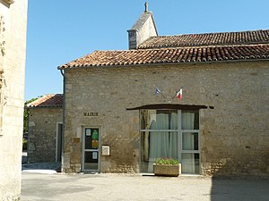
 Former town hall (Mairie) of Saint-Amant-de-Bonnieure |
||
Saint-Amant-de-Bonnieure ( Occitan : Sant Amanc ) is a former French community with 363 inhabitants (at January 1, 2017) in the department of Charente in the region Nouvelle-Aquitaine .
With effect from January 1, 2018, the formerly independent municipalities of Saint-Angeau , Sainte-Colombe and Saint-Amant-de-Bonnieure were merged to form the Commune nouvelle Val-de-Bonnieure and have the status of a Commune déléguée in the new municipality . The administrative headquarters are in Saint-Angeau.
location
Sainte-Colombe is located about 27 kilometers northeast of Angoulême on the Bonnieure River .
Population development
| year | 1962 | 1968 | 1975 | 1982 | 1990 | 1999 | 2006 | 2013 |
| Residents | 389 | 357 | 309 | 315 | 297 | 314 | 349 | 352 |
| Source: Cassini and INSEE | ||||||||
Attractions
- Saint-Amant church from the 12th century, monument historique since 1981
- Saint-Amant house from the 15th century, a historic monument since 1983
Web links
Commons : Saint-Amant-de-Bonnieure - Collection of images, videos and audio files


