Salem, New Hampshire
|
|
This article was on the basis of substantive defects quality assurance side of the project USA entered. Help bring the quality of this article to an acceptable level and take part in the discussion ! The following deficiencies should be corrected before this marking can be removed: Much room for improvement, as there is practically no content. |
| Salem | ||
|---|---|---|
 Salem Square (1908) |
||
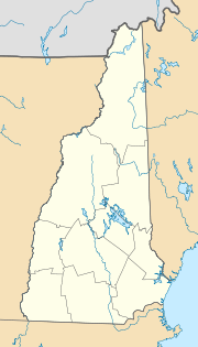
| Location in New Hampshire | ||
|
|
||
| Basic data | ||
| Foundation : | 1751 | |
| State : | United States | |
| State : | New Hampshire | |
| County : | Rockingham County | |
| Coordinates : | 42 ° 47 ′ N , 71 ° 12 ′ W | |
| Time zone : | Eastern ( UTC − 5 / −4 ) | |
| Residents : | 28,871 (as of 2011) | |
| Population density : | 451.1 inhabitants per km 2 | |
| Area : | 67 km 2 (approx. 26 mi 2 ) of which 64 km 2 (approx. 25 mi 2 ) are land |
|
| Height : | 40 m | |
| Area code : | +1 603 | |
| FIPS : | 33-66660 | |
| GNIS ID : | 0873713 | |
| Website : | townofsalemnh.org | |
| Mayor : | Patrick M. Hargreaves | |
Salem is a city in the US state of New Hampshire founded in 1751 with just under 30,000 inhabitants.
Salem is the eighth largest city in New Hampshire with an area of 67.0 km² . It is located in the south of the state in Rockingham County . The Interstate 93 connects it to Boston , Massachusetts .
Personalities
Sons and daughters of the town:
- Pamela Gidley (1965-2018), actress
- Chris Sununu (* 1974), politician
Connected to the city:
- Silas Betton (1768–1822), American politician
- John H. Sununu (born 1939), politician
- John E. Sununu (born 1964), politician
- Paul Neurath , game developer and entrepreneur
Web links
Commons : Salem, New Hampshire - Collection of pictures, videos, and audio files
Individual evidence
- ↑ Salem, NH (PDF; 555 kB) on nhes.nh.gov
- ^ New Hampshire - Largest Cities on geonames.org

