Saleys
| Saleys | ||
|
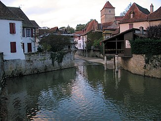
The river in Salies-de-Béarn |
||
| Data | ||
| Water code | FR : Q74-0400 | |
| location | France , Nouvelle-Aquitaine region | |
| River system | Adour | |
| Drain over | Gave d'Oloron → Gaves Réunis → Adour → Atlantic Ocean | |
| source | on the municipal boundary of Vielleségure and Ogenne-Camptort 43 ° 20 ′ 14 ″ N , 0 ° 42 ′ 20 ″ W |
|
| Source height | approx. 240 m | |
| muzzle | in the municipality of Carresse-Cassaber in the Gave d'Oloron Coordinates: 43 ° 29 ′ 44 ″ N , 1 ° 1 ′ 10 ″ W 43 ° 29 ′ 44 ″ N , 1 ° 1 ′ 10 ″ W |
|
| Mouth height | approx. 10 m | |
| Height difference | approx. 230 m | |
| Bottom slope | approx. 4.7 ‰ | |
| length | 49 km | |
| Small towns | Salies-de-Bearn | |
The Saleys is a river in France that runs in the Pyrénées-Atlantiques department in the Nouvelle-Aquitaine region . It rises on the municipal boundary of Vielleségure and Ogenne-Camptort , generally drains in a north-westerly direction and after 49 kilometers flows into the Gave d'Oloron as a right tributary in the municipality of Carresse-Cassaber .
Places on the river
(Order in flow direction)
- L'Hôpital-d'Orion
- Salies-de-Bearn
- Carresse , municipality of Carresse-Cassaber
- Cassaber , municipality of Carresse-Cassaber
Web links
Commons : Saleys - collection of images, videos and audio files
Individual evidence
- ↑ Source geoportail.gouv.fr
- ↑ estuary geoportail.gouv.fr
- ↑ a b The information on the length of the river is based on the information about the Saleys at SANDRE (French), accessed on September 1, 2013, rounded to full kilometers.
