Sambhal
| Sambhal | ||
|---|---|---|
|
|
||
| State : |
|
|
| State : | Uttar Pradesh | |
| District : | Sambhal | |
| Sub-district : | Sambhal | |
| Location : | 28 ° 35 ' N , 78 ° 34' E | |
| Height : | 293 m | |
| Area : | 16 km² | |
| Residents : | 221,000 (2011) | |
| Population density : | 13,813 inhabitants / km² | |
| Website : | www.nagarpalikasambhal.in | |
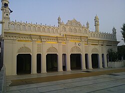
| Mosque Madrasa Siraj ul Uloom | ||
Sambhal ( Hindi : संभल; Urdu : سنبھل) is a city in the Indian state of Uttar Pradesh .
Sambhal is located in the north Indian plain 130 km east of the federal capital New Delhi and 30 km southwest of Moradabad . The Ganges flows south 30 km west of the city. The city is the administrative seat of the district of the same name founded in 2011/2012 . Main roads connect Sambhal with the surrounding cities of Moradabad, Bulandshahr , Hasanpur and Chandausi .
As a city, Sambhal has the status of Nagar Palika Parishad . The city is divided into 33 wards . At the 2011 census, Sambhal had 221,000 inhabitants. The area is dominated by Muslims . These make up 77.67% of the population. 22% are followers of Hinduism .
Web links
Commons : Sambhal - collection of images, videos and audio files

