San Joaquín (Querétaro)
| San Joaquín | ||
|---|---|---|
|
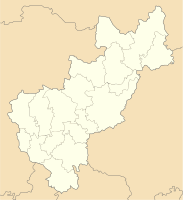
Coordinates: 20 ° 55 ′ N , 99 ° 34 ′ W San Joaquín on the Queretaro map
|
||
| Basic data | ||
| Country | Mexico | |
| State | Querétaro | |
| Municipio | San Joaquín | |
| City foundation | 1682 | |
| Residents | 1985 (2010) | |
| Detailed data | ||
| surface | 0.9 km 2 | |
| Population density | 2,206 inhabitants / km 2 | |
| height | 2420 m | |
| Post Code | 76550 | |
| Time zone | UTC −6 | |
| Website | ||
| San Joaquín - town view | ||
| San Joaquín - town center | ||
San Joaquín is a place with about 2,000 inhabitants in the north of the Mexican state of Querétaro . Because of its historic city center, it is one of the Pueblos Mágicos . San Joaquín is the administrative seat of a municipality ( municipio ) with a number of villages and hamlets with a total of around 9,000 inhabitants.
location
San Joaquín is located in a valley of the Sierra Gorda in the central highlands of Mexico at an altitude of approx. 2410 to 2450 m . Santiago de Querétaro , the capital of the state, is about 140 km (driving distance) to the southwest. The climate is temperate because of the altitude and by Mexican standards it is quite rainy.
Population and economy
| year | 2000 | 2005 | 2010 |
| Residents | 1,549 | 1,906 | 1,985 |
Only a small part of the inhabitants of the community, who mostly belong to the Pame Indios, speak the regional language; and Nahuatl , the language of the Aztec conquerors has become rare; Colloquial language is mostly Spanish. Several small craft workshops and shops have sprung up in the city; Smaller furniture manufacturers have also set up shop in the outskirts.
history
Although older traces have been discovered, the visible history of the high valley begins with the two classic ruins of Las Ranas and Toluquilla , whose cultural classification is controversial due to the lack of inscriptions and figures. The main reason for the two settlements - probably abandoned in the 9th century - was the extraction of minerals that were used as dyes ( above all cinnabar , sulfur and mercury ). In the 13th century immigrant Pame and Jonace Indians settled in the region, which were later partly displaced by the Otomí and Chichimeks . The karst and strongly rugged Sierra Gorda was ignored by neither the Aztecs nor the Spanish conquistadors . In the 16th century the mining industry was revived and the Augustinian order initially took on the task of proselytizing the Indians, but by a decree of the viceroy Luis de Velasco y Castilla from 1609 this task was transferred to the Franciscan order , whose success initially remained low . On November 13, 1682, San Nicolás de Tolentino was founded, but 40 years later the place was re-established, which was given the name of San Joaquín in the 19th century and municipal rights in 1941.
Attractions
- The houses, which are painted in different bright colors, and the sometimes narrow and gently sloping streets give the place a very attractive overall picture.
- The three-aisled parish church ( Iglesia de San Joaquín ) is a new building from the 2nd half of the 20th century. It has a bell tower integrated into the facade , a dome above the crossing and a flat-closing apse .
- On the outskirts is the monument of the Glorieta Piedra Redonda , built in 1970 and dominated by a round millstone , which is intended to commemorate the mineral and ore extraction and its processing in the region.
- Surroundings
- Approx. 1 km north of the village (driving distance approx. 3 km) is the pre-Hispanic ruins of Las Ranas .
- Approx. The ruins of Toluquilla are 8 km southeast of the village .
- Approx. 3 km southwest of the village is the stalactite cave Gruta de los Herrera, which has only been explored since 1978 .
- In the vicinity of the place there are 3 places with rock paintings of unknown age ( El Durazno, Los Azogues and San Francisco Gatos ).
- There is also a waterfall at El Durazno .
Web links
- San Joaquín - Photos + Info (INAFED, Spanish)
- San Joaquín - Photo + Info (Spanish)
- San Joaquín, church - photos


