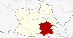
Sankhaburi district
|
Sankhaburi สรรคบุรี |
|
|---|---|
| Province: | Chai Nat |
| Surface: | 354.8 km² |
| Residents: | 66,429 (2013) |
| Population density : | 192.8 U / km² |
| ZIP : | 17140 |
| Geocode : | 1805 |
| map | |

|
|
Amphoe Sankhaburi ( Thai : อำเภอ สรรคบุรี ) is a district ( amphoe - administrative district) in the southern part of the province of Chai Nat . The Chai Nat Province is located in the northern part of the central region of Thailand .
geography
Neighboring districts are (from west clockwise): Amphoe Hankha , Mueang Chai Nat and Sapphaya the province of Chai Nat, the Amphoe In Buri and Bang Rachan the province of Sing Buri and Amphoe Doem Bang Nang Buat of the province of Suphan Buri .
administration
Provincial Administration
Sankhaburi County is divided into eight tambon ("subdistricts" or "parishes"), which are further subdivided into 92 muban ("villages").
| No. | Surname | Thai | Muban | Pop. |
|---|---|---|---|---|
| 1. | Phraek Si Racha | แพรก ศรีราชา | 16 | 15,932 |
| 2. | Thiang Thae | เที่ยงแท้ | 10 | 6.233 |
| 3. | Huai Krot | ห้วย กรด | 9 | 8,970 |
| 4th | Pho Ngam | โพ งาม | 13 | 7,653 |
| 5. | Bang Khut | บาง ขุด | 12 | 7,227 |
| 6th | Dong Khon | ดง คอน | 16 | 12,082 |
| 7th | Don Kam | ดอน กำ | 8th | 2,896 |
| 8th. | Huai Krot Phatthana | ห้วย กรด พัฒนา | 8th | 5,436 |
Local administration
There are eight municipalities with "small town" status ( Thesaban Tambon ) in the district:
- Huai Krot (Thai: เทศบาล ตำบล ห้วย กรด ) consisting of the complete tambon Huai Krot.
- Pho Ngam (Thai: เทศบาล ตำบล โพ งาม ) consisting of the complete tambon Pho Ngam.
- Bang Khut (Thai: เทศบาล ตำบล บาง ขุด ) consisting of the complete tambon Bang Khut.
- Don Kam (Thai: เทศบาล ตำบล ดอน กำ ) consisting of the complete tambon Don Kam.
- Huai Krot Phatthana (Thai: เทศบาล ตำบล ห้วย กรด พัฒนา ) consisting of the complete tambon Huai Krot Phatthana.
- Phraek Si Racha (Thai: เทศบาล ตำบล แพรก ศรีราชา ) consisting of parts of the Tambon Phraek Si Racha.
- Dong Khon (Thai: เทศบาล ตำบล ดง คอน ) consisting of the complete tambon Dong Khon.
- Sankhaburi (Thai: เทศบาล ตำบล สรรคบุรี ) consisting of parts of the Tambon Phraek Si Racha.
There is also a " tambon administration organizations " ( องค์การ บริหาร ส่วน ตำบล - Tambon Administrative Organizations, TAO)
- Thiang Thae (Thai: องค์การ บริหาร ส่วน ตำบล เที่ยงแท้ ) consisting of the complete tambon Thiang Thae.
Individual evidence
- ↑ 2013 population statistics ( Thai ) Department of Provincial Administration. Retrieved August 25, 2014.
Web links
- More information about Amphoe Sankhaburi from amphoe.com (inactive, Thai)
Coordinates: 15 ° 3 ' N , 100 ° 10' E
