Santa Maria de Avioso
| Santa Maria de Avioso | |||||
|---|---|---|---|---|---|
|
|||||
| Basic data | |||||
| Region : | Norte | ||||
| Sub-region : | Porto metropolitan area | ||||
| District : | postage | ||||
| Concelho : | Maia | ||||
| Coordinates : | 41 ° 16 ′ N , 8 ° 36 ′ W | ||||
| Residents: | 4490 (as of June 30, 2011) | ||||
| Surface: | 4.88 km² (as of January 1, 2010) | ||||
| Population density : | 920 inhabitants per km² | ||||
| Postal code : | 4475-617 | ||||
| politics | |||||
| Address of the municipal administration: | Junta de Freguesia de Santa Maria de Avioso Rua de Avioso, nº75 4475-617 Santa Maria de Avioso |
||||
Santa Maria de Avioso is a former municipality in the city of Maia in northern Portugal .
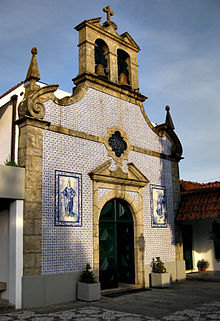
The townscape is determined by the Igreja de Santa Maria de Avioso from the 17th / 18th centuries. Century. She is the patron saint of the place, consecrated to St. Mary .
administration
Santa Maria de Avioso was a parish ( freguesia ) in the district ( concelho ) of Maia , in the district of Porto . On June 30, 2011 the community had 4490 inhabitants on an area of 4.9 km².
As part of the administrative reorganization in Portugal in 2013, the municipality of Santa Maria de Avioso was merged with the municipalities of São Pedro de Avioso , Gemunde , Gondim and Barca to form the new municipality of Castêlo de Maia .
Web links
- Map of the Freguesia Santa Maria de Avioso at the Instituto Geográfico do Exército
Individual evidence
- ↑ a b www.ine.pt - indicator resident population by place of residence and sex; Decennial in the database of the Instituto Nacional de Estatística
- ↑ Overview of code assignments from Freguesias on epp.eurostat.ec.europa.eu
- ^ Publication of the administrative reorganization in the Diário da República gazette of January 28, 2013, accessed on June 19, 2014


