Sattelberg (Grazer Bergland)
| Sattelberg | ||
|---|---|---|
|
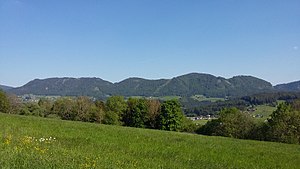
Weizklamm, Wolfsattel, Wachthaussattel, Lärchsattel and Gösser (2017) |
||
| height | 1088 m above sea level A. | |
| location | Styria | |
| Mountains | Grazer Bergland , foothills east of the Mur | |
| Dominance | 2.4 km → Harl | |
| Notch height | 383 m ↓ Knopperhof | |
| Coordinates | 47 ° 15 '9 " N , 15 ° 32' 33" E | |
|
|
||
The Sattelberg is up to 1088 m above sea level. A. high, karst ridge of the Grazer Bergland between the Weizklamm in the east and the Raabklamm in the west of the Weiz district in Styria . The local population uses the plural when referring to this ridge, i.e. the saddle mountains, as there are four elevations that can be seen from afar, three of which have the suffix “-sattel”.
Before the construction of the Weizklammstraße in 1877, the crossing over the Wachthaussattel was the most important connection from Passail to Weiz, as the way through the creek bed of the Weizbach along the Weizklamm was very difficult. There are several small alpine pastures and pastures on almost every elevation of the Sattelberg, but in return for the use of wood, they are only used by the residents south of the mountain.
structure
The individual elevations of the Sattelberg are from northeast to southwest:
- Wolfsattel, 1080 m, elongated ridge between Weizklamm and the cross on the Wachthaussattel
- Wachthaussattel, 950 m, name of the first mountain saddle
The elevation southwest of the mountain saddle also bears the name Wachthaussattel and protrudes about 100 meters above the mountain saddle.
- Lärchsattel, 1088 m, the name of the second mountain saddle and the elevation southwest of it, which is also the highest elevation on the Sattelberg.
- Gösser, 1030 m, is the name of the elevation that drops significantly along the Gösserwand towards Raabklamm and Arzberg
history
At the point of the cross on the Wachthaussattel at 950 meters above sea level, the border between the dominions Stubenberg - Stubegg and the parishes Weizberg - Passail was already in the Middle Ages . At the time of the Ottomans' advance towards Central Europe ( Turkish wars ) and the time of the plague , Wolf von Stubenberg built a guardhouse on this border around 1665. The cross, which has served as a pilgrimage station since then, was built around this time.
tourism
Several hiking trails lead over or along the Sattelberg, for example the Naaser Höhlenweg (over) or the Montanhistorisches Lehrpfad (along). The saddle mountains offer very good views of southern Eastern Styria, the Raab and Weiz gorges and the Passail basin in various places. The Grasslhöhle and Katerloch show caves are on the south side of the mountain.
Web links
Individual evidence
- ^ Leopold Farnleitner, Franz Hauser, Hans Ritz: Weiz. History and stories. Ed .: Weizer Zeitung. 1997, p. 369 .
- ↑ Federal Office for Metrology and Surveying (Ed.): Austrian Map 1: 50,000 BMN 6703 . tape 134 . Federal Office for Metrology and Surveying, Vienna 1998.
- ↑ Unknown: Cross on the guard house saddle . Guard house saddle 2008.

