Saußbach (Wolfsteiner Ohe)
| Saußbach | ||
| Data | ||
| Water code | EN : 1788 | |
| location | Bavarian forest | |
| River system | Danube | |
| Drain over | Wolfsteiner Ohe → Ilz → Danube → Black Sea | |
| origin | Confluence of Rothbach and Teufelsbach 48 ° 54 ′ 24 ″ N , 13 ° 35 ′ 46 ″ E |
|
| Source height | approx. 770 m above sea level NN | |
| confluence | with the Reschbach to Wolfsteiner Ohe in the Buchberger Leite near Freyung Coordinates: 48 ° 49 '9 " N , 13 ° 31' 4" E 48 ° 49 '9 " N , 13 ° 31' 4" E |
|
| Mouth height | 548 m above sea level NN | |
| Height difference | approx. 222 m | |
| Bottom slope | approx. 6.9 ‰ | |
| length | 32.1 km from the source of the Teufelsbach |
|
| Catchment area | 111.77 km² | |
| Runoff at the Linden gauge |
MNQ MQ MHQ HHQ (1993) |
669 l / s 2.24 m³ / s 30.1 m³ / s 127 m³ / s |
| Small towns | Freyung | |
| Communities | Mauth | |
The Saußbach ( called Saußwasser on some sections ) is a brook in the Lower Bavarian district of Freyung-Grafenau .
course
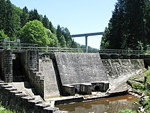
The Saußbach arises from the Teufelsbach and the Rothbach . At Waldmühle, east of Hohenröhren , the Rothbach meets the Teufelsbach from the north. From Mauth the stream flows past Annathal (municipality of Mauth) towards Freyung . There the Saußbach flows around a ledge on which Wolfstein Castle is located. Then the water enters a gorge (the Buchberger Leite ). At the beginning of the gorge, the Saußbach is dammed into a lake and most of the water is fed into a tunnel to generate energy (see Freyung Carbide Works ). A more than 50 m high bridge on which the B 12 runs spans the reservoir . About two kilometers further, the brook meets the Reschbach and together with it forms the Wolfsteiner Ohe .
use
Like many streams in the area, the Saußbach was previously used for wood drift . Today several small hydropower plants use the stream to generate energy.
Individual evidence
- ↑ a b BayernViewer
- ↑ a b Directory of the brook and river areas in Bavaria - Isar to Inn river area, page 154 of the Bavarian State Office for the Environment, as of 2016 (PDF; 3.3 MB)
- ^ Bavarian flood news service

