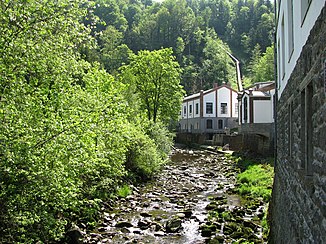
Wolfsteiner Ohe
| Wolfsteiner Ohe | ||
|
Wolfsteiner Ohe at the Freyung carbide plant |
||
| Data | ||
| Water code | EN : 1788 | |
| location | Freyung-Grafenau district , Lower Bavaria | |
| River system | Danube | |
| Drain over | Ilz → Danube → Black Sea | |
| confluence | from the left Saußbach and right Reschbach in the Buchberger Leite west of Freyung 48 ° 49 ′ 9 ″ N , 13 ° 31 ′ 4 ″ E |
|
| Source height | 548 m above sea level NN | |
| muzzle | At Fürsteneck from the left into the Ilz coordinates: 48 ° 43 '6 " N , 13 ° 27' 16" E 48 ° 43 '6 " N , 13 ° 27' 16" E |
|
| Mouth height | approx. 335 m above sea level NN | |
| Height difference | approx. 213 m | |
| Bottom slope | approx. 9.5 ‰ | |
| length | 22.5 km from the confluence of Saußbach / Reschbach |
|
| Catchment area | 372.47 km² | |
| Discharge at the Fürsteneck A Eo gauge : 370 km² Location: 2 km above the mouth |
NNQ (02/16/1963) MNQ 1951–2006 MQ 1951–2006 Mq 1951–2006 MHQ 1951–2006 HHQ (12/21/1993) |
1.32 m³ / s 2.34 m³ / s 8.02 m³ / s 21.7 l / (s km²) 75.4 m³ / s 197 m³ / s |
| Left tributaries | Osterbach | |
The Wolfsteiner Ohe is a left tributary of the Ilz in the Bavarian Forest in the Bavarian district of Freyung-Grafenau , over 22 kilometers long on its name run and, together with its longest upper course, almost 55 kilometers long , which flows into it from the left at Fürsteneck .
geography
Headwaters
The Wolfsteiner Ohe has two upper reaches which are quite long compared to its name segment, the Saußbach , which is longer on its entire line, with a richer catchment area and the left, and the Reschbach . These arise on or a little further across the border with the Czech Republic . They flow in approximately the same direction first southwards and then south-westwards and unite somewhat west of the Freyung through which the Saußbach flows to the Wolfsteiner Ohe.
course
For about its first five kilometers, the Wolfsteiner Ohe moves westward in a narrow, wooded Kerbtal to the village of Ringelai , at the end of which it bends on the southern run into a further valley, which offers space for other places. Towards the end of this longest section of the run, the valley narrows and forests reach back down to the shore. Finally, it takes in the Osterbach approaching from the east-northeast from the border triangle Germany / Czech Republic / Austria and then flows its last two kilometers westwards again until it flows into the Ilz from the left at the foot of Fürsteneck .
Tributaries
From the confluence to the mouth. Selection, partly with length and catchment area.
- Saußbach , with the upper course Teufelsbach , left upper course, 32.1 km and 111.8 km²
- Reschbach , in sections also Reschwasser , right upper course, 22.8 km and 72.2 km²
- Buchberger Bach , with the upper course Geißbach , from the right at the Buchbergmühle von Hohenau , 4.1 km and 4.1 km²
- Grasreutbach , from the left in Ringelai , 2.6 km and 1.6 km²
- Schwemmbach , with the upper reaches Hinterwiesbach and then a lower section of the actually longer Thomasbach , from the right in Ringelai, 3.6 km and 11.9 km²
- Kaltenbrunner Bach , from the left at the Göschlmühle from Markt Perlesreut
- Durchlaßbach , from the right at the Perlesreut hammer mill
- Bannholzbach , from the left in front of the Heiblmühle von Perlesreut, 2.4 km and 5.1 km²
- Hartzerreuter Bach , from the right near Fürsteneck -Simpoln
- Altenreutbach , from left to Markt Röhrnbach -Altreut
- Osterbach , from the left at Röhrnbach-Holzhof, 34.4 km and 134.7 km²
Others
The first section of the Wolfsteiner Ohe between Freyung and Ringelai is called the Buchberger Leite and has been a nature reserve since 1961 .
From March to May, the river is used for kayaking in approved sections .
The level of the Wolfsteiner Ohe is officially recorded at Fürsteneck.
Web links
Individual evidence
- ↑ a b c d Length and catchment area according to: Directory of stream and river areas in Bavaria - Isar to Inn river area, page 154 of the Bavarian State Office for the Environment, as of 2016 (PDF; 3.3 MB)
- ^ German Hydrological Yearbook Danube Region 2006 Bavarian State Office for the Environment, p. 222, accessed on October 4, 2017, at: bestellen.bayern.de (PDF, German, 24.2 MB).
- ↑ Length and catchment area according to: Directory of brook and river areas in Bavaria - Isar to Inn river area, page 155 of the Bavarian State Office for the Environment, as of 2016 (PDF; 3.3 MB)
- ↑ a b c d Length and catchment area according to: Directory of stream and river areas in Bavaria - Isar to Inn river area, page 156 of the Bavarian State Office for the Environment, as of 2016 (PDF; 3.3 MB)
- ↑ River Guide River Guide (Austria) ( page no longer available , search in web archives ) Info: The link was automatically marked as defective. Please check the link according to the instructions and then remove this notice. Retrieved January 20, 2009
- ↑ Level Fürsteneck / Wolfsteiner Ohe ( page no longer available , search in web archives ) Info: The link was automatically marked as defective. Please check the link according to the instructions and then remove this notice. at the HND Bayern , accessed on September 5, 2011
