Sawabi Islands
| Sawabi Islands | ||
|---|---|---|
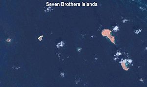
| NASA satellite image | ||
| Waters | Red Sea , Indian Ocean | |
| Geographical location | 12 ° 28 ′ N , 43 ° 25 ′ E | |
|
|
||
| Number of islands | 6th | |
| Main island | Kaḏḏa Dâbali | |
| Total land area | 0.9 km² | |
| Residents | uninhabited | |
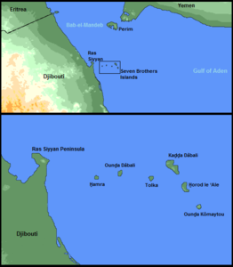
| Situation map and sketch map | ||
The Sawabi Islands ( Arabic جزر السوابع Juzur as-Sawabiʿ , DMG Ǧuzur as-Sawābiʿ or al-Juzur as-sabʿa /الجزر السبعة / al-Ǧuzur as-sabʿa / 'the seven islands'; French also Sept Frères , English Seven Brothers , Seven Brothers' ), not to be confused with the Omani Sawadi Islands are one of six uninhabited islands existing to Djibouti owned archipelago in the Strait of Bab al Mandeb between the Red Sea and the Indian Ocean . They belong to the Obock region .
The islands from west to east:
- al-Hamra (West Island, Red Island)
- al-Muzdawidscha (Ounda Dabali, Île Double)
- as-Sufla (Tolka, Île Basse)
- al-Kubra (Kaḏḏa Dâbali, Big Island)
- Ash-Sharqiyya (Horod le 'Ale, East Island)
- al-Dschanubiyya (Ounda Komaytou, South Island)
The main island of Kadda Dabali takes up over half of the area of the archipelago, around 50 hectares out of a total of 90 hectares. At 114 meters high, it is also the tallest of the six islands.
The Ra’s Siyyān peninsula is sometimes referred to as part of the archipelago. Ra's Siyyān culminates in a 138 meter high volcano . The islands are at a distance of 4.5 to 14 kilometers from Ra's Siyyān.
Web links
- Seven Brothers Islands Beaches ( March 24, 2011 memento in the Internet Archive ) accessed on February 13, 2014 at archive.is
Individual evidence
- ↑ Traveling Luck for Sawâbi`, Obock, Djibouti found on travelingluck.com on February 13, 2014


