
Schleierfalls (Starzlachklamm)

The Schleierfälle in the Starzlachklamm are a geotope northeast of Sonthofen in the Oberallgäu district . The 12 meter high sliding waterfall forms the entrance to the Starzlachklamm .
geology
On the east side of the Illertal, not far from Sonthofen-Winkel below the Grünten , the Starzlach plunges over a steep step into a gump at the end of the gorge . The steep step consists of solidified gray Nummulite limestone , into which the stream bed has cut. The pending in the range of the waterfall Eocene Nummulitenkalke fall to 35 ° west-southwest, and are in the course of the gorge by an intense break tectonic in stress. The Nummulite limestone reaches a total thickness of around 80 meters in the area of the Starzlachklamm . The Starzlachklamm was created in the core of the tectonically complicated Starzlachmulde , which descends to the southwest . Nummulite limestone is one of the more seldom exposed rock sequences in the Helvetica in the Allgäu . The large foraminiferous nummulites, as key fossils for the Old Tertiary, indicate a formation on the northern shelf of the Tethys .
The unfolding of the Alps began at the end of the Old Tertiary . In the process, the rocks were folded and packets of rock pushed over to the north as a pile of roofs . The Nummulitenkalke are part of the so-called Grünten-Nappe , a part of the Säntis- Nappe, which originated in Eastern Switzerland and was pushed into the Allgäu via Vorarlberg . The Grünten Nappe probably sheared off as early as the Lower Oligocene and, when it was thrust, carried away the rocks of the Helveticum, which was once more paleogeographically northern.
The following fossils can be found here: Nummulites Murchisoni , Nummulites perforatus , Nummulites distanz , Assilina exposens , Assilina granulosa as well as molluscs , bivalves , bryozoa , echinoderms and lithothamnias.
Protection and tourist use
The Schleierfalls in the Starzlachklamm NE of Sonthofen have been classified by the Bavarian State Office for the Environment as a geoscientific geotope (geotope no. 780R034). The Starzlach Gorge with the Schleier Falls, which is accessible by a hiking trail, is now a geotouristic excursion point in the Allgäu Geopark . For several years now, the Schleier Falls have also been one of the main attractions for guided canyoning tours through the gorge. The tour ends by sliding over the steep step into the Gump. The Schleierfalls in the Starzlachklamm are protected as a natural monument.
Inlet of the waterfall

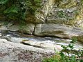
Incised stream bed in the upper part of the waterfall

Lower part of the waterfall

Waterfall with a pool

Mineralized nummulite limestone from the gorge

Canyoning at the Schleierfall


_(1).jpg)

_(28).jpg)
See also
Individual evidence
- ↑ a b Klaus Schwerd, Rudolf Ebel, Hermann Jerz: Geological map of Bavaria 1:25 000, explanations for sheet no. 8427 Immenstadt i. Allgäu . Munich 1983, p. 64 ff .
- ↑ Geotope data sheet of the Bavarian State Office for the Environment: Geotope no. 780R034 Schleierfälle in the Starzlachklamm NE of Sonthofen , accessed on February 9, 2016
- ↑ The Starzlachklamm near Sonthofen. (No longer available online.) Geopark Allgäu, archived from the original on November 19, 2010 ; accessed on February 11, 2016 . Info: The archive link was inserted automatically and has not yet been checked. Please check the original and archive link according to the instructions and then remove this notice.
literature
- Dieter Richter : Allgäu Alps . In: Manfred P. Gwinner (Ed.): Collection of Geological Guides, 3rd edition. Issue 77, Gebr. Borntraeger, Berlin and Stuttgart 1984, ISBN 3-443-15038-1 , 253 pp.
- OM Reis: Die Nummulitenschichten in the Grüntener Bogen , Geognostisches Jahrbuch, volume 39, Munich 1926, p. 22ff.
- B. Höpfner: Stratigraphy and facies distribution in the southern Helvetian Cretaceous-Tertiary boundary layers of the central Allgäu as well as comparisons to the east and west. Doctorate University of Munich, Munich, 1970, 128 pp.
- Klaus Schwerd: Helvetikum, Ultrahelvetikum, Feuerstätter blanket, Rhenodanubian flysch and Arosa zone between Burgberg and Hindelang, excursion guide, excursion G on April 8, 1983 , annual reports and communications from the Upper Rhine Geological Association, Volume 65, Stuttgart 1983, pp. 99–112
- Klaus Schwerd, Rudolf Ebel, Hermann Jerz : Geological map of Bavaria 1:25 000, explanations for sheet no. 8427 Immenstadt i. Allgäu . Munich 1983, 258 pp.
- Franke Preschke: Waterfalls in Germany . Hannover 2001, ISBN 3-00-007346-9 , 158 pp.
Web links
Coordinates: 47 ° 31 '53.9 " N , 10 ° 18' 35.9" E