
Otting Castle

Otting Castle is a two-storey complex, the main building of which is provided with a corner tower. It is located in a slightly elevated position on the outskirts of Otting on the edge of the Nördlinger Ries in the Donau-Ries district .
history
The village of Otting, first mentioned in writing in 830, had a medieval castle, which was built in the 11th and 12th and later destroyed. In 1610 today's castle was built next to the old castle ruins. In the following time, several families owned the castle: Schenk von Stauffenberg , von Freyberg , von Westernach , the Späth family from Zwiefalten and von Rehling . In 1811 the castle became the property of Baron Carl Friedrich Stephan von Schönfeld . The latter was the half-brother of King Maximilian I Joseph of Bavaria . In 1817 the baronial von Schönfeld family was raised to the rank of count. From then on, the family called themselves von Otting and Fünfstetten . In 1856 Maximilian Joseph Graf von Otting and Fünfstetten sold the area to the Munich factory owner Oskar Kurzel, who in 1899 sold the castle to the Allgemeine Deutsche Creditversicherungsanstalt . From 1904 the castle owners changed several times. For 17 years (1905–1921) the castle had its own brewery.
The palace chapel Mater Dolorosa , built in the 18th century and owned by the Otting parish since 1930, was one of the most important pilgrimage churches in northern Swabia in the 19th century . Gravestones adorned with coats of arms remind of the former castle owners.
Today the castle is owned by three families, one at a time. After a renovation, a hotel and restaurant were opened in one part of the castle.
The gatehouse is in danger of collapsing; However, due to an ongoing legal dispute, it is unclear who is responsible for the redevelopment (as of March 2019).

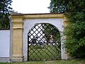
Gate entrance and side wing

Side wing in the inner courtyard
Castle wall with a view of the park and the south side of the castle

Castle chapel


Web links
- http://www.schloss-otting.de/
- http://www.bayern-web.com/de/artikel/schloss-otting.html
- http://www.vg-wemding.de/index.php?id=516,214
Individual evidence
- ↑ Thomas Balbierer: Neighborhood dispute: There it is now, the poor gate. In: www.sueddeutsche.de. March 11, 2019, accessed March 11, 2019 .


Castles: Amerdingen Castle | Belzheim Castle | Donaumünster Castle | Fünfstetten Castle | Gansheim Castle | Genderkingen Castle | Old Hemerten Castle | Hemerten New Castle | Hirschbrunn Palace | Hochaltingen Castle | Hohenaltheim Palace | Kleinerdlingen Castle | Leitheim Palace | Lierheim Palace | Monheim Castle | Moritzschlösschen | Oberndorf Castle | Otting Castle | Oettingen Castle | Old Castle Rain | Reimlingen Castle | Schweinspoint Castle | Tagmersheim Castle | Tapfheim Castle | Old Castle Wallerstein | Wallerstein Castle
Castles and ruins: Alerheim castle ruins | Gosheim Castle (exited) | Graisbach Castle | Harburg Castle | Castle high-rise | Lechsgemünd Castle (exited) | Mangoldstein Castle (exited) | Niederhaus Castle | Rauhaus Castle (exited) | Steinhart Castle (Old Castle) | Tagmersheim moated castle (dismissed) | Thurneck Castle (exited) | Wellwart Castle (Wöllwarth) (removed)
Tower hill castles (all gone): Dornstadt castle stables
Castle stables (lost, unknown castles): Burgstall Bollstadt | Hagburg | Burgstall Maihingen | Burgstall Mühlberg | Burgstall Steinhart (Judenbuck) | Turenberc | Burgstall Weiherberg
Coordinates: 48 ° 52 '27.1 " N , 10 ° 47' 39.1" E