
Schlossberg (Tännesberg)
| Schlossberg | ||
|---|---|---|
 Tännesberg with Schlossberg |
||
| height | 692 m | |
| location | Bavaria , Germany | |
| Mountains | Upper Palatinate Forest | |
| Coordinates | 49 ° 32 '4 " N , 12 ° 19' 45" E | |
|
||
| particularities | Highest point in Tännesberg | |


The Schlossberg is 692 m above sea level. NN the highest point of the place Tännesberg , which belongs to the Upper Palatinate district of Neustadt an der Waldnaab . The entire municipality is located in the Northern Upper Palatinate Forest Nature Park . From the almost tree-free summit of the Schlossberg, the visitor has a panoramic view of the hill country of the central Upper Palatinate.
Castle complex
Tännesberg Castle stood on the Schlossberg in the Middle Ages . From this strategically favorable point one had eye contact with Burg Leuchtenberg , Burg Wildstein and Burg Gleiritsch . The hill fort was owned by the Paulsdorfer in the 12th century . "A distinction was made between a lower and an upper house (house = castle) ...". Between 1394 and 1397 it was sold to the Count Palatine Ruprecht I and Ruprecht II . During the Thirty Years War the castle was taken and destroyed. Remnants of the foundations of the former castle complex on the Schlossberg are still preserved.
Calvary
Around 1817 the ruins were torn down. The Schlossberg was transformed into a Calvary . 14 stations of the cross were built and the tomb and the grotto "Christ in Chains" were built. Carl Burger , who was born in Tännesberg, renovated the Stations of the Cross between 1925 and 1929. In 2001 the Oberpfälzer Waldverein renewed the stations of the cross with the support of the Northern Upper Palatinate Forest Nature Park .
Resurrection Chapel
After the foundations of the former castle complex had been exposed in 1932, the Heimatschutzverein built the Resurrection Chapel in 1934. In 1996 the building was rebuilt in its current form by the Upper Palatinate Forest Association.
Grazing
Around 1980 the south side of the Schlossberg was cut down. The landscape maintenance of the steep and stony terrain has been done by sheep since then .
Picture gallery

Tännesberg with Schlossberg

Schlossberg

Tännesberg (1680)
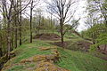
Burgstall Tännesberg


literature
- Dieter Bernd: Vohenstrauss . In: Historical Atlas of Bavaria , part of Old Bavaria . Series I, issue 39. Komm. Für Bayerische Landesgeschichte, Munich 1977, ISBN 3-7696-9900-9 ( digitized version ).
- Richard Hoffmann, Georg Hager: The art monuments of the Kingdom of Bavaria, Upper Palatinate and Regensburg . Volume II, single volume 8: District Office Vohenstrauß . Munich 1907, reprint ISBN 3-486-50438-X .
- Alois Köppl: From the history of the community Gleiritsch. Gleiritsch community 1988, 2nd edition.
- Karl Primbs: History and Genealogy of the Paulsdorfer , in VHVO, Vol. 40, 1886, Appendix I and II.
Individual evidence
- ↑ Alois Köppl, From the history of the community Gleiritsch. Gleiritsch municipality 1988, 2nd edition, p. 43
- ↑ Karl Primbs, history and genealogy of Paul Strand, in VHVO, Vol. 40, 1886, Supplement I and II
- ^ Richard Hoffmann, Georg Hager: The art monuments of the Kingdom of Bavaria, Upper Palatinate and Regensburg . Volume II, single volume 8: District Office Vohenstrauß . Munich 1907, reprint ISBN 3-486-50438-X , p. 97
- ↑ Dieter Bernd: Vohenstrauss . In: Historical Atlas of Bavaria , part of Old Bavaria . Series I, issue 39. Komm. Für Bayerische Landesgeschichte, Munich 1977, ISBN 3-7696-9900-9 , p. 94 ( digitized version ).
- ↑ Information on the notice board on the Schlossberg
- ↑ Information on the notice board on the Schlossberg
