
Schullwitzbach
| Schullwitzbach | ||
 The Schullwitzbach in the Lieblingstal near Dittersbach |
||
| Data | ||
| location | Dresden , Dürrröhrsdorf-Dittersbach | |
| River system | Elbe | |
| Drain over | Wesenitz → Elbe → North Sea | |
| source | in Reitzendorf (Dresden), on Kalkteich 51 ° 1 '54 " N , 13 ° 54' 46" O |
|
| Source height | 308.5 m above sea level HN | |
| muzzle | in the Wesenitz coordinates: 51 ° 2 ′ 2 ″ N , 13 ° 59 ′ 20 ″ E 51 ° 2 ′ 2 ″ N , 13 ° 59 ′ 20 ″ E
|
|
| length | 8.1 km | |
| Catchment area | 11.5 km² | |
| Flowing lakes | Reitzendorfer limestone pond, Schullwitz mermaid pond | |
The Schullwitzbach is a right tributary of the Wesenitz in the east of Dresden .
course
The Schullwitzbach begins at the limestone pond between Reitzendorf and Schullwitz (districts of Dresden), flows in a north-easterly direction through the Schullwitz Nixenteich and reaches Schullwitz, then it flows in an easterly direction through the Eschdorf district , where it reaches the city limits of Dresden.
Its lower course and the confluence with the Wesenitz are in the area of the municipality of Dürrröhrsdorf-Dittersbach . From the hard ponds near Rossendorf, the Kalte Bach flows south through Dittersbach and flows into the Schullwitzbach, shortly before it flows into the Wesenitz.
From the lime pond to the Schullwitz mermaid pond, the Schullwitzbach is largely natural. In the village of Schullwitz, the stream is dammed in several ponds (village, school, mill pond).
In Schullwitz it is mostly built in and piped in places. Behind Schullwitz, the brook flows through a meadow area, in this area the brook was exposed and designed to be close to nature. In Eschdorf the Schullwitzbach mostly runs next to the state road Pirna-Radeberg and is fortified on the street side by a bank wall. From Eschdorf the stream is in a natural state.
It then flows in the district of Dürrröhrsdorf-Dittersbach through a wooded valley below the road Wünschendorf - Dittersbach and flows into the Wesenitz in the palace gardens of Schloss Dittersbach .
Tributaries
- Aspichbach
- Wilder Weiher Graben
- Marktweggraben
- Schullwitz Wiesengraben
- Eschdorf Spiegelweggraben
- Eschdorf-Zaschendorfer Grenzbach
- Eschdorfer Weggraben
- Triebenbergbach
- Rossendorfer water
- Cold brook
Former mills
Due to its low flow rate, there were only a few mills on this stream:
- Mill in Schullwitz (mentioned in 1808)
- Obermühle or Bienertmühle in Eschdorf, where Gottlieb Traugott Bienert was born in 1813
- Niedermühle in Eschdorf (district Rosinendörfchen)
Favorite valley
The lower section of the Schullwitzbachtal in Dittersbach is known as the Lieblingstal. The Lieblingstal was opened up by Johann Gottlob von Quandt around 1840, in 2006 a marked hiking trail through the Lieblingstal was laid out by the Quandt-Verein Dittersbach (based on a hiking guide from 1908). The following monuments were created again:
- The Hubertus chapel has been rebuilt by the Quandt Association. The old chapel dates from 1840 and was derelict.
- The King Anton Monument was completely redesigned. The inscription reads: "King Anton of Saxony - founder of the first Saxon constitution of 1831 ". The bust is a copy of the King Anton monument in Dresden by Ernst Rietschel (1835).
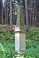
- The Saxon constitutional column (constitution column), which was also completely rebuilt, is provided with the inscription on the front: “In memory of the foundation of the first Saxon constitution in 1831 by King Anton with the statutes”.
- The Teufelsbrücke is a sandstone arch bridge over the Schullwitzbach. It is a very old bridge that has been completely renovated.
- Above the Lieblingstal is the castle with the " Schöne Höhe " observation tower , which Quandt had built. On the slope of the mountain you can visit the Kaiserstuhl (stone bench) and the dwarf cave.
gallery

In the favorite valley near Dürrröhrsdorf-Dittersbach

Hubertus chapel in the Lieblingstal near Dürrröhrsdorf-Dittersbach

King Anton Monument in Lieblingstal
Constitution stone in Lieblingstal

Devil's Bridge in Lieblingstal
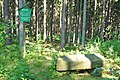
Kaiserstuhl above the Lieblingstal

Dwarf cave above Lieblingstal


Web links
Individual evidence
- ↑ a b c d State capital Dresden, The Lord Mayor, Environment Agency (ed.): Schullwitzbach water profile . ( Online as PDF ; 4 MB - as of September 30, 2011).