
Silence

In the late Middle Ages, Schweid (t) was understood to mean the surrounding area with the suburbs of a city, especially in the Rhineland, which was mapped on a map .
etymology
Schweid (t) is probably a word from the Ripuarian language that is related to the Old Norse “sveit” or “sweid” (district, region, Gau). At the beginning of the 18th century it can also be found in Bergisch and Sauerland as a term for land or pasture ownership.
development
Cologne, which was well mapped in the Middle Ages ( Cologne city view from 1531 by Anton Woensam , Cologne city view from 1570 by Arnold Mercator ) focused the representation exclusively on the inner-city areas, so that the following sweat maps with the coverage of the surrounding area represented a valuable cartographic addition. In 1590 the city council of Cologne had commissioned a map of the Bannmeile and Burgbann with the indication of the "bylie Dorffernn and Hoeffen with indication of their Sweyß or Vhedryfften in front of each gate as from old herkhomen with the swartzer linien abgetzeignett". It follows that in the late medieval Kölsch these maps of the area were called "Sweyß".
Cologne Schweidkarte by Abraham Hogenberg
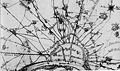
Abraham Hogenberg - Schweidkarte with detail Aachener Straße-western suburbs (1609)

Abraham Hogenberg - Schweidkarte with detail Nippes-Mauenheim-Weidenpesch (1609)

Abraham Hogenberg - Schweidkarte with detail Ehrenportzer Schweidt (1609)

Abraham Hogenberg - Schweidkarte with detail of the surroundings of the Weißhaus (1609)


This map may have served as the preparatory work for the most famous Cologne Schweidkarte by Abraham Hogenberg , who concentrated on the districts outside the city limits while largely neglecting urban details. The Kölner Schweid (pasture district) is a field and landmark boundary and encompassed the entirety of the districts of the five Cologne farmers ' banks ("Boorbank"; a kind of farmers' association). Schweid here means the land ownership of the peasant communities and peasant benches, which are limited by landmarks . It concerns the grazing rights of the farmer's benches within the castle ban of the city of Cologne. The card had the Latin title "Descriptio agri civitatis Coloniensis (cum suis limitibus)", in medieval German "Description and demolition of the Collnisch Schweidts, with its remarks, road divisions, surrounding villages, heuseren, lands". The copper engraving, consisting of four leaves, measures 61.5 × 90 cm and shows the imperial double-headed eagle and the Cologne coat of arms in the upper part, and the Latin inscription on a panel on the left. The map extends south to Brühl , west to Hermülheim , north to Worringen ; Distances are noted in league hours. The plan is detailed and factual and largely dispenses with the playful decorations typical of the Baroque era. It draws the surrounding area (suburbs and settlements) outside of the city on the left bank of the Rhine and thus gives important information about existing (or not yet) localities and their names at the time. Today's Butzweiler was still called "Potzweyler" for him, it lies between "Oßendorff" (today's Cologne-Ossendorf ) and "Buckelmeuntt" ( Cologne-Bocklemünd ). The consideration of buildings on the Hogenberg-Schweid and later Schweidkarten suggests the existence of a road customs office. The map shows five sectors as castle railways. The exact dating of the Hogenberg-Schweid is unclear, the maps are likely to have been made between 1604 and 1610.
The following welding cards

Joan Blaeu - Coloniensis Archiepiscopatus (1645)

Joan Blaeu - Cologne sweat card (1663)

Covens & Mortier - Germany Map (1730)

Covens & Mortier - Cologne sweat map (1735)


_-_Geographicus_-_Germaniae-covensmortier-1720.jpg)

The Dutchman Joan Blaeu also published a sweat map of Cologne ("Collen") as part of his Atlas Major in 1645. It recorded the Archdiocese of Cologne and mapped an area in the north to Wachtendonk , in the east to Haltern , in the south to Waldbröl and in the west to Aachen . Nikolaus Person (* 1693 in Longwy , † July 15, 1710 in Mainz ) brought out his Kölner Schweid in 1700, which covered all suburbs and settlements of Cologne on the left bank of the Rhine. Between 1730 and 1735 the map "Schweid von Köln" was published by Johannes Covens (1697–1774) and Cornelis Mortier (1699–1783) , the most important Dutch cartographers of the time. Her “Descriptio agri Civitatis Coloniensis” on a scale of about 1: 60000 was created with the dimensions 37.5 × 52 cm. The map covers an area as far as Frechen in the west, Brühl in the south and Roggendorf / Thenhoven in the north. While the Cologne city map from 1752 focused the view on the city again, on April 2, 1791 Joseph Otto (creative period 1763–1791) brought out the map “Schweid von Köln” with the depiction of the castle ban of the city of Cologne (Cologne and the surrounding area with Bischofsweg and Burgbann). In the French era , the Rhineland had to be topographically mapped on the personal orders of Napoleon under the command of Colonel Jean Joseph Tranchot . His tranchot card from 1807/1808 is also considered a sweat card.
Individual evidence
- ↑ Franz Ed. Christ Dietrich, Altnordisches Lesebuch , 1843, p. 279.
- ↑ Wikiling about sveit. (No longer available online.) Archived from the original on March 4, 2016 ; accessed on July 21, 2017 . Info: The archive link was inserted automatically and has not yet been checked. Please check the original and archive link according to the instructions and then remove this notice.
- ↑ a b B. G. Teubner-Verlag, Journal for German Education , Volume 23, 1908, p. 196.
- ^ Verlag Siedlungsforschung, Siedlungsforschung: Archeology, History, Geography , Volumes 1–2, 1983, p. 139.
- ↑ "with the neighboring villages and farms and display of their sweat or cattle drifting in front of each gate, drawn with black lines as is traditionally used"
- ↑ "with its districts, divisions, surrounding villages, houses and lands"
- ↑ Jost Auler , Richtstättenarchäologie , Volume 3, 2012, p. 279.
- ^ Verlag Siedlungsforschung, Siedlungsforschung: Archeology, History, Geography , Volumes 1–2, 1983, p. 141.