
Sefinen Lütschine
|
Sefinen Lütschine Sefi-Litschena |
||
|
|
||
| Data | ||
| Water code | CH : 1844 | |
| location |
Bernese Alps
|
|
| River system | Rhine | |
| Drain over | Weisse Lütschine → Lütschine → Aare → Rhine → North Sea | |
| source | smaller corn snow on Jegihoren 46 ° 31 '18 " N , 7 ° 49' 59" O |
|
| Source height | approx. 1980 m above sea level M. | |
| muzzle | west of Lauterbrunnen -Rütti Coordinates: 46 ° 32 '47 " N , 7 ° 53' 57" E ; CH1903: 635 319 / 155121 46 ° 32 '47 " N , 7 ° 53' 57" O |
|
| Mouth height | 893 m above sea level M. | |
| Height difference | approx. 1087 m | |
| Bottom slope | approx. 12% | |
| length | approx. 8.7 km | |
| Catchment area | 27.05 km² | |
| Discharge A Eo : 27.05 km² at the mouth |
MQ Mq |
1.5 m³ / s 55.5 l / (s km²) |
The Sefinen Lütschine is a creek about 9 kilometers long that flows from the Sefinental into the Lauterbrunnen valley in the Bernese Oberland and flows into the Weisse Lütschine from the left .
geography
course
The Sefinen Lütschine rises from a small firn at around 1980 m above sea level. M. on the eastern slope of the Jegihoren .
At Firten flows at about 1420 m above sea level. M. the similarly large Sefibach from the left to. It continues through the Sefinental to 1200 m above sea level from the left . M. the Schiltbach flows into. Then it moves on through the valley below Gimmelwald . On the last kilometer, the Sefinen Lütschine overcomes an altitude difference of 250 meters and reaches the Lauterbrunnen valley . The Sefinenfall is also located there .
Finally it flows into the vicinity of Rütti at 893 m above sea level. M. from the left into the Weisse Lütschine.
Catchment area
The catchment area of the Sefinen Lütschine has a size of about 27 km², with the highest point in the catchment area, the Gspaltenhorn, at an altitude of 3436 m above sea level. M. achieved. Another well-known mountain in the catchment area is the Schilthorn .
The mean height of the catchment area is 2110 m above sea level. M. , the minimum height is 894 m above sea level. M.
It consists of 12.3% wooded area , 28.4% agricultural area , 0.1% settlement area , 6.6% glacier / firn, 1.0% water area and 51.6% from unproductive areas.
Area distribution

Tributaries
Inflows from the source to the mouth with name, orographic direction , length in kilometers, catchment area in km², mouth location, mouth height. The names of the streams come from the WebGIS of the canton of Bern, the data from swisstopo .
- Ahornigraben ( left ), 0.4 miles
- Feistbodengraben I ( left ), 0.6 km
- Feistbodengraben II ( left ), 0.5 km
- Feistbodengraben III ( left ), 0.7 km
- Selfibach ( left ), 3.6 km, 6.86 km², 0.41 m³ / s
- Weschbächli II ( left ), 1.0 km
- Ortlouwenenwanggraben ( right ), 0.4 km
- Inners Diimiggräbli ( right ), 0.4 km
- Ussers Diimiggräbli ( right ), 0.4 km
- Marteswanggräbli ( left ), 0.7 km
- Inners Zwilleswanggräbli ( right ), 0.1 km
- Ussers Zwilleswanggräbli ( right ), 0.6 km
- Fyschtertrittgräbli ( left ), 0.2 km
- Teifgraben ( left ), 0.4 miles
- Wyssbortbächli ( right ), 0.3 km
- (Bach from the) Bir Brunnstuben ( right ), 0.2 km
- Bärenpfadgraben ( right ), 0.5 km
- Inner Rässegggraben ( right ), 0.2 km
- Schiltbach ( Geisställenbach ) ( left ), 4.0 km, 4.1 km²
- Usser Rässegggraben ( right ), 0.3 km
- Milchbach ( right ), 0.1 km
- Grosses Rufibächli ( right ), 0.2 km
- Chlyns Rufibächli ( right ), 0.2 km
Hydrology
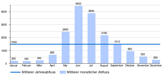
At the confluence of the Sefinen Lütschine in the Weisse Lütschine, its modeled mean flow rate (MQ) is 1,500 l / s. Their discharge regime type is nivo glaciaire and their discharge variability is 17.
Individual evidence
- ↑ a b c Geoserver of the Swiss Federal Administration ( information )
- ↑ a b c d Topographical catchment areas of Swiss waters: sub-catchment areas 2 km². Retrieved January 20, 2020 .
- ↑ "Hidden behind the mean values" - the variability of the discharge regime , p. 119
- ↑ The discharge variability describes the extent of the fluctuations in the mean discharge of individual years around the long-term mean discharge value.