
Shimabara
| Shimabara-shi 島 原 市 |
|||
|---|---|---|---|
|
|||
| Geographical location in Japan | |||
| Region : | Kyushu | ||
| Prefecture : | Nagasaki | ||
| Coordinates : | 32 ° 47 ' N , 130 ° 22' E | ||
| Basic data | |||
| Surface: | 82.78 km² | ||
| Residents : | 43,553 (October 1, 2019) |
||
| Population density : | 526 inhabitants per km² | ||
| Community key : | 42203-7 | ||
| Symbols | |||
| Flag / coat of arms: |
 |
||
| Tree : | Camphor tree | ||
| Flower : | Ume | ||
| town hall | |||
| Address : |
Shimabara City Hall 537 Uenomachi Shimabara -shi Nagasaki 855-8555 |
||
| Website URL: | http://www.city.shimabara.lg.jp/ | ||
| Location of Shimabaras in Nagasaki Prefecture | |||
 |
|||

Shimabara ( Japanese 島 原 市 , -shi ) is a city in Nagasaki Prefecture on Kyushu Island in Japan .
geography
It is located on the northeast tip of the Shimabara Peninsula named after the city . In the east it borders on the Ariake Bay, in the west on the Unzen volcano .
history
On May 21, 1792, the Fugen-dake volcano erupted in the Unzen volcanic complex . A short time later, the eastern flank of the Mayuyama collapsed as a result of an earthquake, triggering an avalanche that slid into the ocean at speeds of up to 200 km / h. The resulting 20 meter high tsunami destroyed the city of Shimabara almost completely and more than 15,000 people were killed. This was the most momentous geological eruption in Japan to date.
Shimabara was named an independent city ( shi ) on April 1, 1940 .
traffic
- Train:
- Shimabara-Tetsudō Line: to Isahaya
Attractions
The most popular tourist destination is Shimabara Castle and the nearby Samurai Road.
Shimabara also has numerous onsen . There is so much natural spring water here - hot and cold - that it runs through the streets in canals.
Koi swim in the channels of the picturesque Carp Route .

Shimabara Castle
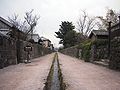
The Samurai Street in Shimabara
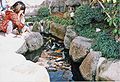
Koi in channels on the Shimabara Carp Route

Shimabara City Hall
sons and daughters of the town
- Yūji Hyakutake (1950–2002), amateur astronomer
- Suehiro Maruo (* 1956), mangaka and illustrator
Neighboring cities and communities
Web links
Independent cities ( shi ): Gotō | Hirado | Iki | Isahaya | Matsuura | Minamishimabara | Nagasaki (administrative headquarters) | Ōmura | Saikai | Sasebo | Shimabara | Tsushima | Ounces
Higashisonogi-gun : Hasami | Higashisonogi | Kawatana | Kitamatsura-gun : Odika | Saza | Minamimatsura-gun : Shinkamigoto | Nishisonogi-gun : Nagayo | Togitsu