
Tsushima (Nagasaki)
| Tsushima-shi 対 馬 市 |
|||
|---|---|---|---|
 |
|||
| Geographical location in Japan | |||
|
|||
| Region : | Kyushu | ||
| Prefecture : | Nagasaki | ||
| Coordinates : | 34 ° 12 ' N , 129 ° 17' E | ||
| Basic data | |||
| Surface: | 708.81 km² | ||
| Residents : | 29,337 (October 1, 2019) |
||
| Population density : | 41 inhabitants per km² | ||
| Community key : | 42209-6 | ||
| Symbols | |||
| Flag / coat of arms: |
 |
||
| Tree : | Chionanthus retusa | ||
| Flower : | Rhododendron mucronulatum var. Ciliatum | ||
| Bird : | pheasant | ||
| town hall | |||
| Address : |
Tsushima City Hall in 1441 Kokubu, Izuhara-machi Tsushima shi Nagasaki 817-0022 |
||
| Website URL: | http://www.city.tsushima.nagasaki.jp | ||
| Location of Tsushimas in Nagasaki Prefecture | |||
 |
|||

Tsushima ( Japanese 対 馬 市 , - shi ) is a Japanese city that encompasses the entire island of Tsushima and the Tsushima sub-prefecture on the Korean Strait . It is located north of Nagasaki .
history
The sea battle at Tsushima took place near the island in 1905 .
The city was created on March 1, 2004 through the merger of the six until then independent Chō Izuhara ( 厳 原 町 , -chō ), Mitsushima ( 美 津 島 町 , -chō ) and Toyotama ( 豊 玉 町 , -chō ) of the Shimoagata district , as well as Mine ( 峰 町 , -chō ), Kamiagata ( 上 県 町 , -chō ) and Kamitsushima ( 上 対 馬 町 , -chō ) of Kamiagata County . Both districts were dissolved and the city thus encompasses the entire island and the entire sub-prefecture.
economy
The main industries are fishing , pearl fishing and tourism . Tsushima is connected by ferry connections with Hakata in Kyushu and Busan in South Korea . Busan and Guam ( American island of the Mariana Islands ) are twin cities of Tsushima.
traffic
- Street:
- National Road 382
sons and daughters of the town
Attractions
Izuhara, the largest city and main port of the island with around 15,000 inhabitants when all places on Tsushima were amalgamated in 2004, was the castle town of the Sō family for 700 years . Their tombs can be seen in the Banshoin Temple, founded in 1615 on the outskirts of Izuhara, whose gate is the oldest surviving building on the entire island. Behind the temple is the third largest cemetery in Japan, which was laid out in terraces in a forest and can be reached via a long stone staircase lined with stone lanterns on both sides.
Izuhara is nicknamed "the city of 10,000 stones", which refers to the fact that the remains of old walls made of large rubble stones can be seen all over the city. Numerous houses are built on the same foundations and bases. Among other things, the remains of old samurai houses are noteworthy in several places in the city center, which are surrounded by massive stone walls.
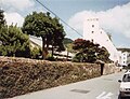
On the outskirts of Izuhara, the remains of the Kane Ishi Jo castle complex, built in 1592 by Toyotomi Hideyoshi during a campaign to Korea, are worth a visit. The castle was renovated in 1669. The massive castle wall, built of quarry stones and surrounded by a moat, is primarily preserved. In the interior of the complex, the stones of the pond of the former castle garden stand out, of which nothing else has been preserved. The gate tower of the castle was rebuilt in 1990 in the original style.
At the edge of the village of Kuta, 3 km southwest of Izuhara, the historic port of Ofunae is worth seeing. It is a port that was built in 1663 and was privately owned.
In the middle of the island, the Shinto shrine Watatsumi Jinja is worth a visit. It is located near the seaside village of Ni-I in a grove of pine trees. A row of five toriis stands out in front of the shrine, two of which are in the water.

Kane Ishi Jo Castle

Banshoin Temple

graveyard
Wall of a samurai house

Ofunae port facility

Watatsumi Jinja Shrine


Individual evidence
- ^ Karl Baedeker: Japan , p. 176. Ostfildern-Kemnat 1999
- ↑ Yamakei Guide 21, Vol. 20: Kyushu , p. 417. Kawasaki 2001. ISBN 4-635-01090-2
- ↑ Chris Taylor: Japan , p. 631.Stefan Loose Verlag, Berlin 1998
- ↑ Yamakei Guide 21, Vol. 20: Kyushu , p. 418. Kawasaki 2001. ISBN 4-635-01090-2
Web links
Independent cities ( shi ): Gotō | Hirado | Iki | Isahaya | Matsuura | Minamishimabara | Nagasaki (administrative headquarters) | Ōmura | Saikai | Sasebo | Shimabara | Tsushima | Ounces
Higashisonogi-gun : Hasami | Higashisonogi | Kawatana | Kitamatsura-gun : Odika | Saza | Minamimatsura-gun : Shinkamigoto | Nishisonogi-gun : Nagayo | Togitsu