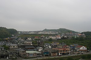
Nagayo (Nagasaki)
| Nagayo-chō 長 与 町 |
||
|---|---|---|
| Geographical location in Japan | ||
|
|
||
| Region : | Kyushu | |
| Prefecture : | Nagasaki | |
| Coordinates : | 32 ° 50 ' N , 129 ° 53' E | |
| Basic data | ||
| Surface: | 28.81 km² | |
| Residents : | 41,630 (October 1, 2019) |
|
| Population density : | 1445 inhabitants per km² | |
| Community key : | 42307-6 | |
| Symbols | ||
| Tree : | Ume | |
| town hall | ||
| Address : |
Nagayo Town Hall 659 - 1 , Urerigō Nagayo -chō, Nishisonogi-gun Nagasaki 851-2185 |
|
| Website URL: | http://webtown.nagayo.jp | |
| Location Nagayos in Nagasaki Prefecture | ||
Nagayo ( Japanese 長 与 町 , - chō ) is a community that is located in the central part of the Japanese prefecture of Nagasaki and belongs to the district of Nishisonogi.
In 2003 the municipality had an estimated population of 42,325 inhabitants and a population density of 1,469.11 inhabitants / km² on a total area of 28.81 km².
geography
Nagayo is located about 10 km northeast of Nagasaki on the Ōmura Bay . Because of this location, Nagayo is growing as a satellite town ; and Nagayo Newtown, Nanyōdai, Aobadai, Sunny Town and Midorigaoka Danchi.
Mandarins are grown far and wide in the northern and eastern hills of Nagayo .
Neighboring communities
Nagayo is bordered by Nagasaki, Isahaya, and Togitsu .
Economy and science
Agriculture is the main source of income for Nagayo.
education
University: Siebold University of Nagasaki
High School: Nagasaki Hokuyoudai High School
traffic
railroad
- Train Stations - Honkawachi, Nagayo, Koda and Michinoo
Shipping
- Nagayo Port - Ship Link to Nagasaki Airport (Approximately 2 hours)
Web links
- Official Website (Japanese)


