Shipmeadow
Shipmeadow is a town and parish in the United Kingdom . It is located in the East Suffolk district in the northeast of the English county of Suffolk .
geography
Shipmeadow is south of the Waveney River . It not only forms the northern boundary of the parish, but also that of Suffolk. Neighboring parishes, starting to the east and going clockwise, are Barsham , St Andrew, Ilketshall , St John, Ilketshall , Mettingham , Ellingham and Geldeston . The latter two are in the county of Norfolk .
The community is located in rural areas , roughly halfway between the small towns of Bungay in the west and Beccles in the east. Both are about four kilometers from Shipmeadow. Historically a scattered settlement that was grouped around the parish church located at a road junction, Shipmeadow today has the character of a small street village , which also includes some individual layers . The larger southern part of the district is mainly used for arable farming, the smaller northern part, due to the higher moisture of the soil due to the proximity of the river, as meadow terrain. The area is flat and only rises slightly to the south. The population of Shipmeadow was 140 at the time of the 2011 census, an estimated 147 in 2017. The area of the district is about 3.3 km² , the GSS code of the community is E04009485
history
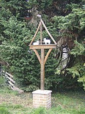
The name stands for a field (meadow) with sheep (sheep) ; two of these animals can be seen on the location sign. In the Domesday Book , emerged in the late 11th century , Shipmeadow is mentioned.
In Shipmeadow was an independent parish of the Church of England , which the consecrated Bartholomew Parish structurally about the 12th century decline. It was dissolved in the 1970s, the church building was subsequently profaned and sold into private hands.
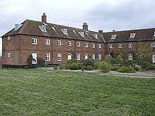
As part of the poor law , after a regional restructuring in the western part of the district, apart from the other buildings, a workhouse was opened in 1767 , which was also responsible for the other communities in the Wangford district. It was closed after the First World War , after which the buildings served as a retirement and nursing home. The complex was later converted into a farm, then converted into apartments in the 1980s. Today it is called Viewpoint Mews .
Due to the occupants of the workhouse, the population of Shipmeadow increased significantly and, based on the censuses carried out every ten years , reached a peak in 1851 with 515 residents. In 1951 there were 218 inhabitants, twenty years later only 75.
Politics and administration
In the system of traditional counties in England , the village within Suffolk belonged to the Wangford Hundred, between 1894 and 1934 to the Rural District Wangford and then to the Rural District Wainford. With the entry into force of the Local Government Act 1972 in April 1974 this went on in the Waveney district . Due to Waveney's merger with Suffolk Coastal , Shipmeadow has been in the East Suffolk district since April 2019 .
Shipmeadow forms an administrative community with Barsham in the form of a combined parish council with a total of four members. Its seat, the Village Hall , is in Barsham.
Buildings
A total of five buildings and facilities in the municipality are classified by Historic England as culturally and historically significant. Of these, the Church of St Bartholomew and a barn are classified as Listed Buildings in Category II *, the workhouse, its chapel and the main house of a farm in Category II.
traffic
Shipmeadow lies on either side of the country road that runs from Homersfield to Beccles via Bungay. Originally classified as A road , it was downgraded in the 1980s and has been designated B1062 ever since. Public transport is covered by an omnibus line that runs from Bungay to Beccles and on to Great Yarmouth .
literature
- William White: Shipmeadow . In: History, Gazetteer, and Directory of Suffolk, and the Towns Near Its Borders , Sheffield 1844, p. 443
- Alfred Suckling: Shipmeadow . In: The History and Antiquities of the County of Suffolk: Volume 1 , Ipswich 1846, pp. 77–81 (English)
- Shipmeadow section in: Wendy Goult: A Survey of Suffolk Parish History , 1990, ISBN 0860551393 . Available online from the County Council's Suffolk Heritage Explorer, PDF, 138 kB
Web links
- Website of the combined municipal council (English)
- Shipmeadow Parish, Local Area Report Statistical data on the population on the NOMIS website operated by the Office for National Statistics , as of 2011 (English)
- Shipmeadow on the website of the Ordnance Survey (English)
- Shipmeadow at Vision of Britain
Individual evidence
- ↑ Population data on the county administration's data server, accessed April 21, 2019. (English)
- ↑ Entry on Shipmeadow at Opendomesday.org, accessed on April 28, 2019. (English)
- ↑ St Bartholomew, Shipmeadow. Church information on a Suffolk Church Buildings website, accessed April 28, 2019.
- ↑ Wangford, Suffolk, on a web site on poor poor legislation in England, accessed April 28, 2019. (English)
- ^ Workhouse Chapel of St James, Shipmeadow. Information on the Workhouse Chapel on a Suffolk Church website, accessed April 28, 2019.
- ↑ Wangford Hundred at Vision of Britain, accessed April 28, 2019.
- ↑ Number 1 in: The English Non-metropolitan Districts (Definition) Order 1972, Schedule 1, Part 35 on the British Government's Law Server, accessed on April 28, 2019. (English)
- ↑ Database query Shipmeadow Parish on the website of Historic England, carried out on April 28, 2019. (English)
- ↑ A145 , A1116 and B1062 on the Society for All British and Irish Road Enthusiasts (SABER) website , accessed April 28, 2019. (English)
- ↑ Query about Shipmeadow on the public transport portal of the county administration, carried out on April 28, 2019. (English)
Coordinates: 52 ° 27 ' N , 1 ° 30' E


