Seven Valleys Cave
| Seven Valleys Cave
|
||
|---|---|---|
|
Entrance to the Seven Valleys Cave |
||
| Location: | District of Tübingen , Baden-Wuerttemberg | |
| Height : | 380 m above sea level NN | |
|
Geographic location: |
48 ° 26 '35 " N , 8 ° 54' 18.3" E | |
|
|
||
| Cadastral number: | 7519/02 | |
| Type: | Natural cave , karst cave in the shell limestone | |
| Lighting: | No | |
| Overall length: | about 207-270 m | |
| Level difference: | about 6 m | |
| Length of the show cave area: |
80–120 m depending on the size of the body | |
| Particularities: | Petrifications in the shell limestone, no stalactites | |
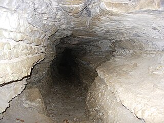
The Sieben-Täler-Höhle (Siebentäler Höhle) or Niedernauer Höhle in the Katzenbachtal between Weiler and Bad Niedernau is the largest cave in the Tübingen district .
description
The cave is located in a former limestone quarry that used to belong to the Katzenbacher Ziegelhütte . The Sieben-Täler-Höhle is a natural cave in the shell limestone in the hamlet of Weiler. The time of origin of the limestone deposits is estimated at around 215 million years. As a long, slender corridor, it cuts through the rock. The Seven Valleys Cave is a very narrow, partly muddy and in places water-bearing cave. Your entrance is less than a meter high. Then it opens up and is initially easy to explore as a long, narrow corridor facing northwest. There is a fork to the right, but it is only a few meters long and cannot be confused with the main course. In the further course you have to climb and crawl. The cave was created by washing away rainwater that seeped from above through cracks and crevices and gradually formed the course of the cave along fissures .
natural reserve
As a designated natural monument, the cave is subject to special protection regulations. It is open from April 15 to November 15, after which the entrance gate is closed to protect the bats that live there . In the front entrance area there are many insects that are adapted to cave life. The cave is not illuminated and not secured. In order to avoid soot build-up, you are asked to enter the cave only with electric light and not with candles or torches.
Directions
From Tübingen to Rottenburg am Neckar towards Weiler. Shortly after Weiler (towards Hirrlingen ) turn right towards Katzenbach . There is a parking lot for hikers on the left after about 250 meters. Across the street at a fork in the road you will find a large hiking map with the history of Weiler and the area. Follow the hiking trail down (left path) into the valley, then turn right at the Katzenbacher Ziegelhütte and follow the Katzenbach in its flow direction for a few hundred meters. The cave is located on the right hand side about ten meters from the path and about 2.5 meters higher than the Katzenbach, at an inconspicuous natural stone quarry covered with weeds. The cave was marked in 2009 with a heavily weathered wooden sign. In the meantime, a new sign from the hamlet of Weiler has been placed directly on the path. In addition to a description of the cave, a cave plan and a representation of the bats living in the cave are printed on it.
literature
- Hans Joachim Haupt: Discover with children - wild caves in the Swabian Alb. Fleischhauer & Spohn, Bietigheim-Bissingen 2002, p. 38ff, ISBN 3-87230-576-X .

