
Silverfallet
|
Silverfallet
|
|
 Silverfallen-Karlsfors nature reserve |
|
| location | Sweden |
| surface | 46 ha |
| Geographical location | 58 ° 29 ' N , 13 ° 45' E |

|
|
| Setup date | 1991 |
| administration | Västra Götalands län Provincial Administration |
Silverfallet , (translated: Silberfall ) is the short name for the nature reserve "Silverfallen-Karlsfors" in the Swedish municipality of Skövde and part of the European Natura 2000 network . The second part of the name, Karlsfors is the name of the village nearby, which means Karl's rapids in translation .
location
The protected area is about 4 km south of Timmersdala between Lake Lången and the western slope of Billingen , the largest of the western Swedish table mountains , the Västgötabergen . The terrain is largely shaped by the successive rock steps made of limestone , alum slate and sandstone , which make the geological structure of the mountain impressively visible.
Along these natural stairs are the disused limestone and alum shale quarries and the ruins of the Karlsfors lime and alum works, which were the largest of their kind in the Skaraborg region during the first half of the 19th century.
Hydrology
.jpg)
Here the Karlsforsbäck (translated Karlsforsbach ) falls in rapids and several cascades over the broken edges of the various rock levels, overcoming a relatively short distance of 50 to 60 meters in altitude.
The map on the left shows the location of the waterfalls. It is not entirely clear whether the name is derived from the largest waterfall (at the viewpoint) or the entire slope - in any case, both Silverfallet in the singular and Silverfall in plural are in use.
Flora and fauna
The stream, which regularly dries out completely in summer when it rains little, flows through a deciduous forest that consists mainly of ash and elm trees . Common cowslip , liverwort and dark lungwort grow on the lime-rich soil at the upper reaches of the stream .
Birch trees and willows grow on the nutrient-poor Rödfyrshögar soil * . In the vicinity of the waterfalls, the damp stones are covered by a dense lawn of cone-head moss and lime water sleep moss . In spring, the nesting sites for mountain wagtails ( Motacilla cinerea ) and dippers ( Cinclus cinclus ) can be found here.
The sandstone in the lower part of the mountain slope provides an ideal subsoil for conifers such as spruce and pine . Smaller parts of the area are open pastureland, on which forest bells ( Campanula persicifolia ), small meadowsweet ( Filipendula vulgaris ) and golden thistle ( Carlina vulgaris ) thrive.
annotation
gallery

The Karlsforsbach
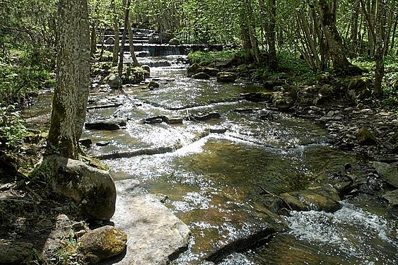
... with rapids over fracture surfaces made of alum slate.
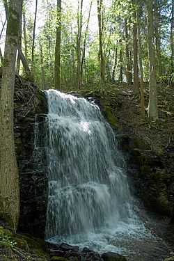
The biggest waterfall

... here in winter.


.jpg)

Ruins of the lime and alum factories
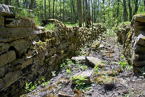
... here a water channel that has fallen dry.


Web links
- Silverfallen-Karlsfors nature reserve (German)
- History of the reserve and the industrial use of the area (German)
- Tip for a hike: Silverfallet, Eahagen, Jättadalen & Höjentorps Slottsruin. (Swedish)
Individual evidence
- ↑ a b World Database on Protected Areas - Silverfallet (English)
- ↑ Hiking in the nature reserve (Swedish)
- ↑ Silverfallen-Karlsfors nature reserve
- ↑ Rödfyrshögar (Swedish)