
Sindelbach (Jagst)
| Sindelbach | ||
 The Sindelbach between Altdorf and Marlach |
||
| Data | ||
| Water code | DE : 238838 | |
| location |
Kocher-Jagst Plains
|
|
| River system | Rhine | |
| Drain over | Jagst → Neckar → Rhine → North Sea | |
| source | between Ingelfingen -Weldingsfelden and -Hermuthausen at latitude 49 ° 19 ′ 6 ″ N , 9 ° 43 ′ 59 ″ E |
|
| Source height | 422 m above sea level NN | |
| muzzle | next to the Marlacher bridge over it in the Jagst coordinates: 49 ° 21 '39 " N , 9 ° 35' 45" E 49 ° 21 '39 " N , 9 ° 35' 45" E |
|
| Mouth height | approx. 217 m above sea level NN | |
| Height difference | approx. 205 m | |
| Bottom slope | approx. 15 ‰ | |
| length | 13.7 km | |
| Catchment area | 26.395 km² | |
| Drain |
MQ |
250 l / s |
The Sindelbach is a small river in the northeast of Baden-Württemberg and flows into the Jagst from the left near the village of Marlach in the municipality of Schöntal in Hohenlohekreis . It is between 13 and 14 km long and thus its longest left tributary.
geography
course
The Sindelbach arises between the Ingelfingen districts of Weldingsfelden and Hermuthausen in Feldgewann Breite as a field path ditch. This longer left source branch often falls dry, a shorter right, which rises less east of Stachenhausen am Forst Fehlenweiler , carries more constant water. The stream flows in a west-north-westerly direction past the Weldingsfeldener hamlet of Eschenhof and then through several districts of Ingelfingen , namely Stachenhausen, where it joins the right source branch, Dörrenzimmern and Eberstal . From the inlet of the Einfangbach in Sindeldorf , a district of Schöntal , it runs north for one and a half kilometers to the confluence of the inconsistent Katzenbrünnles , then for the last one and a half in the old direction through Marlach , where it joins the Jagst from the left .
Tributaries
- Brook fountain ( right ), 1.3 km
- Hungerklinge ( left ), 0.4 miles
- Skyblade ( right ), 0.4 mi
- Tadle ( right ), 0.5 miles
- Brook from the Krautheimer Tal ( right) , 0.9 km
- Brook from the Wörmer valley ( right ), 0.6 km
- Einfangbach ( left ), 1.0 km
- Katzenbrünnle ( right ), 2.0 km
Dates and character
The Sindelbach has been straightened from the source to Stachenhausen and within the localities. Out of town it flows most of the time in its natural river bed, the banks of which are consistently accompanied by diverse vegetation. The catchment area covers 25.6 km²; at the Marlach gauge, an average (1980–1996) flow of 0.25 m³ / s.
Picture gallery

The Sindelbachtal between Eberstal and Sindeldorf

The Sindelbach between Dörrenzimmern and Eberstal
View of the lively murmuring and shining Sindelbach from the south-facing dry slope between Dörrenzimmern and Eberstal

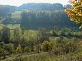
The Sindelbach on its last section between Altdorf and Marlach between orchards


traffic
The district road K 2381 leads through the Sindelbachtal between Stachenhausen and Marlach, which joins the Jagsttalstraße (L 1025) in Marlach. Stachenhausen is also on the L 515 to Krautheim and the federal road 19 between Dörzbach and Künzelsau . The other places in the valley are accessed by further district roads.
See also
Individual evidence
- ↑ Wolf-Dieter Sick : Geographical land survey: The natural space units on sheet 162 Rothenburg o. D. Deaf. Federal Institute for Regional Studies, Bad Godesberg 1962. → Online map (PDF; 4.7 MB)
- ↑ a b According to the contour line image on the geodata viewer.
- ↑ a b Geoportal Baden-Württemberg ( information )
literature
- Hans Mattern : The lower Jagsttal. From Dörzbach to the mouth . Baier, Crailsheim 2005, ISBN 3-929233-27-4 .