Sitka (river)
| Sitka | ||
|
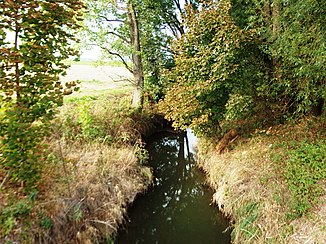
The Sitka just before its mouth at Štěpánov |
||
| Data | ||
| Water code | CZ : 4-10-03-0710 | |
| location | Olomoucký kraj ( Czech Republic ) | |
| River system | Danube | |
| Drain over | Oskava → March → Danube → Black Sea | |
| origin | The confluence of two source streams in the Horní mokřiny forest on the southern slope of the Stránský vrch | |
| Source height | approx. 690 m nm | |
| muzzle | near Chomoutov in the Oskava coordinates: 49 ° 38 '21 " N , 17 ° 14' 36" E 49 ° 38 '21 " N , 17 ° 14' 36" E |
|
| Mouth height | approx. 215 m nm | |
| Height difference | approx. 475 m | |
| Bottom slope | approx. 13 ‰ | |
| length | 35.6 km | |
The Sitka , also known as Huzovka , is a left tributary of the Oskava in the Czech Republic .
geography
The Sitka rises two and a half kilometers west of Ryžoviště in the Lower Jeseníky on the southern slope of the Stránský vrch ( 723 m ) in the wooded ground Horní mokřiny at about 690 m above sea level. NN from two source streams. Via Veveří, Huzová and Dolní Mlýn, it initially runs to the southwest. A narrow, deeply cut valley begins at Mutkov , which stretches in several loops over Horní Žleb and Dolní Žleb to Šternberk . The river then enters the Moravian plain and flows again towards the southwest via Lhota, Lužice , Stádlo, Moravská Huzová, Benátky and Březce. Below the village of Březce, the river is crossed by the railway line between Mohelnice and Olomouc . The lower section of the river runs east parallel to the Oskava past the Chomoutovské jezero quarry. At Chomoutov the Sitka finally empties after 35.63 km at approx. 215 m above sea level. NN into the Oskava, which flows 800 m below the March . The Sitka is the largest tributary of the Oskava.
Tributaries
- Veverský potok ( Eichhorn Brook ) (l), in Veveří ( Eichhorn )
- Arnoltický potok ( Arnsdorfer Bach ) (l), above Huzová ( German house )
- Březina (l), at the Mutkov castle ruins
- Sprchový potok (l), in Šternberk
- Grygava ( Aleschbach ) (l), on Chomoutovské jezero
