Lower Jesen
| Lower Jesen | ||
|---|---|---|
|
Typical landscape of the Lower Jeseníky near Moravian-Kotzendorf from Uhlířský vrch |
||
| Highest peak | Slunečná ( Sun Mountain ) ( 800 m nm ) | |
| location | Czech Republic | |
| part of | Eastern Sudetes | |
|
|
||
| Coordinates | 49 ° 45 ′ N , 17 ° 35 ′ E | |
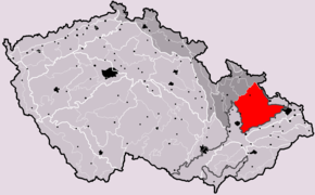
The Lower Jeseníky (also Moravian Jeseníky and Niederes Gesenk , Czech Nízký Jeseník ) is a mountainous region in the east of the Czech Republic . It forms the southeastern branch of the Sudetes .
location

The mountainous region is located in the north of Moravia and in the south of Moravia-Silesia . This is followed by the eastern part of as High dies designated Jeseníky and extends between the northern Silesian Lowland and the Upper Moravian valley basin in the south. The Zuckmanteler Bergland extends to the northeast . In the east it goes over into the Moravian Gate and the Ostrava Basin . It is roughly bounded by the lines between the cities of Olomouc , Ostrava , Krnov and Uničov .
The Lower Jeseníky extends into Moravia and Moravian Silesia, in Moravskoslezský kraj and Olomoucký kraj (in the districts of Okres Bruntál , Okres Nový Jičín , Okres Olomouc , Okres Opava , Okres Ostrava-město and Okres Přerov ).
height
The altitude of the mountains is between 400 and 600 m. The highest peak Slunečná ( Sun Mountain ) in the west reaches 800 m to the east the height decreases to about 350 m . Other peaks are: Fidlův Kopec ( Friedlhübl , 680 m ), Strážná ( 641 m ), Vrchy ( 540 m ), Hůrka ( 530 m ).
geology
The Lower Jeseníky is a mountainous region with relics of volcanic activity. The predominant part of the rocks biting out there are sedimentary rocks of the Kulm , which emerged from older predecessor sediments and volcanic rocks that were formed by intense volcanism in the Devonian Sea. In the Tertiary , the lower Jeseníky was raised due to the orogenic processes, while the Upper Moravian Basin and the Glatzer Kessel were lowered. The resulting fault lines in the earth's crust enabled volcanic activity and this is how the smallest volcanoes in the Czech Republic formed :
- Červená hora ( Rothenberg )
- Velký Roudný ( Great Rautenberg , 750 m )
- Malý Roudný ( Old Rautenberg )
- Uhlířský vrch ( Köhlerberg )
- Venušina sopka ( Messendorfer Berg / Venusberg )
The latter two volcanoes were still active in the early Quaternary .
The area was known for ore mining for non-ferrous and precious metals .
Landscape structure
The Low dies divided into geomorphological units Brantická highlands , Bruntálská highlands , Domašovská highlands , Odra Hills ( Or Bergland ) Slunečná vrchovina ( Sonneberger hills ), Stěbořická pahorkatina ( Stiebrowitzer hills ), Vítkovská vrchovina ( Wigstadtler mountains ) and Tršická pahorkatina ( Trschitzer hills ).
Waters
The Lower Jeseníky is drained by the Oder (tributaries: Moravice , Oppa ) and the March (tributaries: Oskava ( Oskawa ), Sitka , Bystřice ( Feistritz )) and thus forms part of the European watershed . There are also two drinking water reservoirs Slezská Harta and Kružberk .
literature
- Jaroslav Vlach. Nízký Jeseník a přilehlé oblasti . STN, Prague 1958.
- Jaroslav Vlach. Nízký Jeseník a Oderské vrchy . Olympia, Prague 1968.
- Martin Janoška. Nízký Jeseník očima geologa . Univerzita Palackého, Olomouc 2002.
- Do nitra Askiburgionu. Bruntálský slovník naučný: encyklopedie Nízkého Jeseníku . Bruntál: Moravská expedice, 2004.


