Sjoa
| Sjoa | ||
|
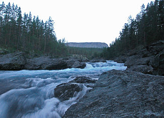
The Sjoa above Heidal |
||
| Data | ||
| Water code | NO : 002.DGZ | |
| location | Innlandet ( Norway ) | |
| River system | Glomma | |
| Drain over | Lågen → Mjøsa → Vorma → Glomma → Skagerrak | |
| source |
Gjende im Jotunheimen 61 ° 29 ′ 42 ″ N , 8 ° 48 ′ 28 ″ E |
|
| muzzle | at Sjoa in Lågen Coordinates: 61 ° 40 ′ 46 " N , 9 ° 31 ′ 58" E 61 ° 40 ′ 46 " N , 9 ° 31 ′ 58" E
|
|
| length | 98 km | |
| Catchment area | 1529 km² | |
The Sjoa River is a water-rich wild river in the Norwegian inland . It begins its course at the eastern end of Lake Gjende near Gjendesheim in the Jotunheimen National Park and flows from there in a north-easterly direction. It crosses the scenic high valley Sjoadalen before it later flows into the Lågen .
The name Sjoa comes from the old Norwegian word hjár , which means the ... that glitters .
The Sjoa flows through a gorge south of the town of Randsverk , known as the Ridderspranget ("knight jump "). According to legend, the knight Sigvat Kvie was able to escape his pursuers after a bride robbery by jumping with his horse at this point over the approximately three meter wide chasm and pushing the following pursuers into the gorge.
In 1973, the river was permanently protected from the use of hydropower by a storting resolution.
Sports
The last kilometers of the river through the Heidalen are very popular kayaking and rafting waters . The Sjoa has different degrees of difficulty , mostly III to IV. The so-called breakthrough - the mouth in the Lågen - is the most difficult (navigable) point and is with it IV-V classified. The Sjoa is considered to be the most famous white water river in Norway.
Web links
- Information about water sports on the river
- More information about rafting
- Sjoa rafting
- Sjoa Adventure
Individual evidence
- ↑ NVE - Sjoa ( Memento of the original of May 21, 2011 in the Internet Archive ) Info: The archive link was automatically inserted and not yet checked. Please check the original and archive link according to the instructions and then remove this notice. (Norway.)

