Smyrna (Tennessee)
| Smyrna | ||
|---|---|---|
|
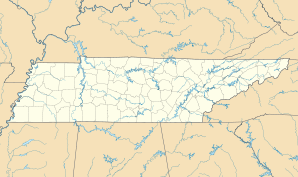
Location in Tennessee
|
||
| Basic data | ||
| Foundation : | 1869 | |
| State : | United States | |
| State : | Tennessee | |
| County : | Rutherford County | |
| Coordinates : | 35 ° 59 ′ N , 86 ° 31 ′ W | |
| Time zone : | Central ( UTC − 6 / −5 ) | |
| Residents : | 39,974 (as of 2010) | |
| Population density : | 676.4 inhabitants per km 2 | |
| Area : | 59.5 km 2 (approx. 23 mi 2 ) of which 59.1 km 2 (approx. 23 mi 2 ) are land |
|
| Height : | 166 m | |
| Postal code : | 37167 | |
| Area code : | +1 615 | |
| FIPS : | 47-69420 | |
| GNIS ID : | 1270735 | |
| Website : | www.smyrnatn.org | |
| Mayor : | Tony Dover | |
Smyrna is a city (with the status of "Town" ) in Rutherford County in the center of the US -amerikanischen state of Tennessee . At the 2010 census , Smyrna had 39,974 inhabitants.
geography
The city is located between Interstate 24 and Tennessee State Route 840 . The closest major city is Nashville at a distance of approximately 25 kilometers to the northwest. Chattanooga is approximately 150 kilometers to the southeast.
history
In the early 19th century, Smyrna started out as a predominantly agricultural community. Since there was a rail link between Nashville and Chattanooga, the place became increasingly important during the American Civil War . An important event from this period was the arrest of Sam Davis, who was accused of espionage . He was hanged by the enemy Union Army because he did not want to divulge any information to them. He was revered as a hero by the Confederation States . Even today, the "Sam Davis Plantation" is the city's most important historical attraction. Smyrna was introduced as a city in 1869 and the state government officially founded it a few years later.
In 1941 the Sewart Air Force Base was set up, which served as a training facility for B-24 bombers, among other things . More than 10,000 people were stationed there between 1950 and 1960. After 1971 the base was split into several locations in Tennessee. Today, Smyrna Airport is used for both civil and military purposes. In the 1970s, new industries settled. Particularly noteworthy is a factory owned by the car manufacturer Nissan , which employs 6,000 workers and produces 500,000 cars a year.
Demographic data
According to the 2010 census , Smyrna had 39,974 people in 14,645 households. The population density was 676.4 inhabitants per square kilometer.
The racial the population was composed of 75.0 percent white, 11.2 percent African American, 0.6 percent Native American, 4.4 percent Asian and other ethnic groups; 2.7 percent were descended from two or more races. Hispanic or Latino of any race was 10.7 percent of the population regardless of ethnicity.
Statistically, 2.55 people lived in each of the 14,645 households.
27.9 percent of the population were under 18 years old, 63.5 percent were between 18 and 64 and 8.6 percent were 65 years or older. 51.3 percent of the population was female.
The median income for a household was 51,505 USD . The per capita income was $ 24,448. 12.2 percent of the population lived below the poverty line.
tourism
Because of its proximity to the Nashville Country Music Center, Smyrna also hosts many folk music events that are very popular both nationally and internationally.
Long Hunter State Park and Cedars Lebanon State Park , each about 20 kilometers away, are popularly visited for their natural beauty.
Air shows are sometimes held at the city's airport .
Sons of the city
- William Barksdale (1821–1863), Confederate General in the American Civil War
- Sam Davis (1842-1863), spy
- Ben H. Guill (1909–1994), politician
- Jalen Ramsey (born 1994), American football player
Individual evidence
- ↑ a b U.S. Census Bureau, State & County QuickFacts - Smyrna, TN ( Memento of the original from March 4, 2012 in the Internet Archive ) Info: The archive link was automatically inserted and not yet checked. Please check the original and archive link according to the instructions and then remove this notice. Retrieved February 17, 2011
