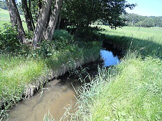
Sockabach
| Sockabach | ||
|
Sockabach near Mühlau |
||
| Data | ||
| Water code | DE : 15836 | |
| location | Lower Bavaria | |
| River system | Danube | |
| Drain over | Kinsach → Danube → Black Sea | |
| source | west of Wascherszell 49 ° 2 ′ 34 " N , 12 ° 35 ′ 41" E |
|
| Source height | over 600 m above sea level NN about | |
| muzzle | in Ascha coordinates: 48 ° 59 '52 " N , 12 ° 38' 24" E 48 ° 59 '52 " N , 12 ° 38' 24" E |
|
| Mouth height | approx. 335 m above sea level NN | |
| Height difference | approx. 265 m | |
| Bottom slope | approx. 37 ‰ | |
| length | 7.1 km | |
| Catchment area | 9.729 km² | |
| Communities | Wiesenfelden, Rattiszell, Falkenfels, Ascha | |
The Sockabach is a creek over seven kilometers long in the Straubing-Bogen district in Lower Bavaria , which flows into the Kinsach from the right in Ascha .
course
The headwaters of the Sockabach are in the west of Wascherszell . From here the brook flows roughly to the south-southeast in a terrain notch. State road 2147 accompanies him at a distance of no more than five hundred meters on or on the left slope.
The stream covers its first two hundred meters in the municipality of Wiesenfelden , then it changes to the corridor of Rattiszell. After taking in a few nameless spring streams on the right, it passes the Pilgramsberg, which is to the north-east on the left . After around four and a half kilometers, it then reaches the eponymous town of Socka , a district of the Falkenfels community . A few hundred meters down at Fahrmühl , it crosses into the district of Ascha , where it loses its last hundred meters of altitude. The flatter lower course in the Kinsachtal begins around Krähhof . After a branch near Mühlau, it crosses under the embankment of Bundesstraße 20 , both branches reunite 700 meters later, now in the local area of Ascha, whose old core is south of the Sockabach. At the church it crosses the old main road and shortly afterwards it flows into the Kinsach from the right .
Web links
- Course and catchment area of the Sockabach on the BayernAtlas
- Basic data on Bavarian rivers. Map of the catchment area. Bavarian State Office for the Environment, accessed on June 10, 2014 .
Individual evidence
- ↑ a b Directory of the brook and river areas in Bavaria - Naab to Isar river area, page 98 of the Bavarian State Office for the Environment, as of 2016 (PDF; 2.8 MB)
