Sohlander Dorfbach
| Sohlander Dorfbach | ||
|
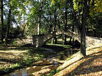
Sohlander Dorfbach with sky bridge |
||
| Data | ||
| location | Saxony | |
| River system | Spree | |
| Drain over | Spree → Havel → Elbe → North Sea | |
| source | southeast of the Kinderberg near Neudorf 51 ° 1 ′ 55 ″ N , 14 ° 23 ′ 24 ″ E |
|
| Source height | 448 m | |
| muzzle | west of the spring mountain in the Spree Coordinates: 51 ° 3 '5 " N , 14 ° 26' 11" E 51 ° 3 '5 " N , 14 ° 26' 11" E |
|
| Mouth height | 281 m | |
| Height difference | 167 m | |
| Bottom slope | approx. 35 ‰ | |
| length | approx. 4.8 km | |
| Left tributaries | Gründelwasser | |
| Communities | Sohland on the Spree | |
The Sohlander Dorfbach is a left-hand tributary of the Upper Spree in Sohland an der Spree in the Saxon district of Bautzen with a length of almost five kilometers.
description
The Sohlander Dorfbach rises southeast of the Kinderberg ( Liščí vrch , 480 m ) near Neudorf . Its upper course initially leads between the Friedrich-August-Höhe ( 469 m ) and the Schwarzen Koppe ( 470 m ) through Neudorf to the east. The stream then takes a north-easterly direction and flows north of the Brandbusch ( 443 m ) and the Hohberg ( 368 m ) through a pronounced valley, in which the local development of the Obersohland and Mittelohland extends. At the Roten Hof ( Mittelohland Castle ), the Oberoderwitz – Wilthen railway bridges the stream. The Sohlander Dorfbach flows west of the spring mountain ( 352 m ) into the Spree.
Its original mouth was northeast of the Red Court ▼ . In the course of the regulation of the Spree in 1947, the Sohlander Dorfbach was extended by a 360 m long old section of the Spree. Since then, the sky bridge , which once bridged the Spree at the White Mill, has been crossing the Sohlander Dorfbach.
Tributaries
The Gründelwasser and several nameless streams flow into the Sohlander Dorfbach.
literature
- Around Bautzen and Schirgiswalde (= values of the German homeland . Volume 12). 1st edition. Akademie Verlag, Berlin 1967, p. 210.
