Loiret (river)
| Loiret | ||
|
The Loiret |
||
| Data | ||
| Water code | FR : K43-0300 | |
| location | France , Center-Val de Loire region | |
| River system | Loire | |
| Drain over | Loire → Atlantic Ocean | |
| source | in Orléans-la-Source , a district of Orléans 47 ° 51 ′ 1 ″ N , 1 ° 56 ′ 14 ″ E |
|
| Source height | approx. 95 m | |
| muzzle | below Saint-Hilaire-Saint-Mesmin in the Loire Coordinates: 47 ° 51 ′ 48 " N , 1 ° 48 ′ 5" E 47 ° 51 ′ 48 " N , 1 ° 48 ′ 5" E |
|
| Mouth height | approx. 89 m | |
| Height difference | approx. 6 m | |
| Bottom slope | approx. 0.5 ‰ | |
| length | 12 km | |
| Catchment area | 282 km² | |
| Right tributaries | Dhuy | |
| Big cities | Orleans | |
| Small towns | Olivet , Saint-Pryvé-Saint-Mesmin | |
|
Mouth of the Loiret (front right) into the Loire |
||
The Loiret is a river in France that runs in the Loiret department of the same name in the Center-Val de Loire region .
geography
Source du Loiret
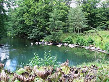
The Loiret rises in the municipality of Orléans , in a newly built district called Orléans-la-Source on the southern outskirts . The Source du Loiret , which is also called “Le Bouillon”, is located in the Parc Floral park . It is a karst spring that is fed underground by the Loire, which partially seeps into the limestones near Jargeau . The spring pot , shimmering turquoise at times, has a diameter of around 21 meters, is around eight meters deep and pours an average of 1300 liters per second. The discharge depends on the water level of the Loire. After one kilometer, the straight flowing Loiret takes on the 34 km long Dhuy flowing in from the right .
course
The Loiret (German: Little Loire ) generally drains in a north-westerly direction through the southern suburbs of Orléans and flows into the Loire as a left tributary after 12 kilometers below Saint-Hilaire-Saint-Mesmin .
Places on the river
Tributaries
- Dhuy (right)
- Bras de Bou (right)
- Bras des Montées (right)
- Pie (left)
Web links
Individual evidence
- ↑ a b geoportail.fr (1: 16,000)
- ↑ a b c The information on the length of the river is based on the information on the Loiret from SANDRE (French), accessed on November 17, 2011, rounded to the nearest kilometer.
- ↑ La rivière du Loiret (French)


