Spaulding Peninsula
| Spaulding Peninsula | ||
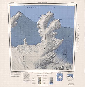
 Topographic map of the Spaulding Peninsula (left half of the picture) |
||
| Geographical location | ||
|
|
||
| Coordinates | 74 ° 26 ′ S , 116 ° 0 ′ W | |
| location | Bakutis Coast , Marie Byrd Land , West Antarctica | |
| Waters 1 | Getz Ice Shelf | |
| Waters 2 | Brennan Inlet | |
| Waters 3 | Sweeny Inlet | |
| length | 11 km | |
The Spaulding Peninsula is a low, icy and 11 km long peninsula on the Bakutis coast of the West Antarctic Marie Byrd Land . It advances into the Getz Ice Shelf between Brennan Inlet and Sweeny Inlet .
The United States Geological Survey mapped the peninsula based on its own measurements and aerial photographs of the United States Navy from 1959 to 1967. The Advisory Committee on Antarctic Names named it in 1977 after Richard Lee Spaulding (* 1938), group leader of a paratrooper unit in the US Navy of operation Deep Freeze 1977, during which he of the year on the Amundsen-Scott South Pole station his 1,000th jump made.
Web links
- Spaulding Peninsula in the Geographic Names Information System of the United States Geological Survey (English)
- Spaulding Peninsula on geographic.org (English)
