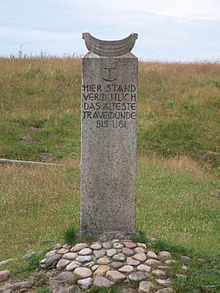
Put the hook
The Stülper Huk is a Huk ( northern German for small, mostly raised peninsula or corner as a coastal shape ) in the lower reaches of the Trave , at a bend in the river across from Pötenitzer Wiek and Dassower See in the Dummersdorfer Ufer nature reserve .
In the 12th century, Henry the Lion had the Huk fortified with a castle because of its strategic location and its elevation (Hirtenberg) above the glacial meltwater channel of the Trave , which, however, was destroyed by the Abodrites around three decades after its creation. The Stülper Huk is now one of the most important ground monuments in the Travemünde area .
history
Archaeological finds from the Stone Age show that the Stülper Huk was probably a popular place even then due to its location. The Huk is mentioned in writing for the first time in the Middle Ages around 1147/1149, as a mighty terrain spur of the Hirtenberg protruding into the Travelauf. In the district of Dummersdorf there are still walls and moats of a former fortification. It is very likely that a moth , also called the tower hill castle, stood there in the High Middle Ages .
Excavations in the 19th and 20th centuries uncovered the remains of the old fortifications on the raised and originally pointed spur of the Hirtenberg. This part of the site, strategically located in a particularly favorable position, only had a narrow entrance in the old days. Among other things, trenches, earth bridges and an interior space of approx. 30-40 m diameter with a stone foundation, which apparently represents the rest of a tower, were uncovered.
The complex was identified as Alt-Travemünde, which is mentioned in the chronicles of Helmold von Bosau and Arnold von Lübeck . Because from the point of view of that time, the course of the Trave ended at this point in the Pötenitzer Wiek, hence “Travemünde”.
Count Adolf II von Holstein had the square fortified after an attack by the Slavic Obotrite prince Niklot in 1147 or 1149. In the event of threatened raids by Slavs or Danes , he gathered an army there. Around 1158 Count Adolf II had to cede Lübeck, which is further upstream, to Duke Heinrich the Lion. Apparently the duke also took over the castle on the Stülper Huk.
The chronicler Arnold von Lübeck reports that the Obotrites, as allies of Emperor Barbarossa against Heinrich the Lion, burned the castle at Stülper Huk during the siege of Lübeck in 1181. Before this warlike act, Henry the Lion was given the eight in 1180 after he had refused to participate in the Second Crusade . Emperor Friedrich Barbarossa had the duke's possessions move in and moved into Lübeck in late summer 1181.
Around 1186/87, Count Adolf III. the reconstruction of the weir system downstream at another point. The castle was relocated and the name Travemünde was transferred to it; the old place lost its meaning. The probable reconstruction of the defense system took place between today's “Rose” street and the lighthouse on the Leuchtenfeld. An exact localization has not yet been successful.
Since the Lübeck Imperial Freedom Letter from 1226, third parties have not been allowed to maintain fortifications two miles away from the lower reaches of the Trave.
See also
literature
- Hermann Hofmeister : The fortifications of northern Albania. Compilation and investigation of the prehistoric and historical castles and fortifications: Volume 1 . Lübeck 1917 (p. 42 ff.); and: 2nd edition, Max Schmidt Verl., 1927.
- Hermann Hofmeister: The prehistoric monuments in the Lübeck state territory. Lübeck 1930.
- Werner Neugebauer: The oldest German trave fortress on the Hirtenberg at the Stülper Huk. In: The car . 1964, pp. 59-65.
- Olaf Klose (ed.): Handbook of the historical sites of Germany . Volume 1: Schleswig-Holstein and Hamburg (= Kröner's pocket edition . Volume 271). 2nd, improved edition. Kröner, Stuttgart 1964, DNB 456882804 .
- Römisch-Germanisches Zentralmuseum Mainz, in connection with the Northwest German and the West and South German Association for Ancient Studies (ed.): Guide to prehistoric and early historical monuments. Volume 10. Hanseatic City of Lübeck - Ostholstein - Kiel . Zabern Verlag, Mainz 1965.
- Uwe Müller (author), Archives of the Hanseatic City of Lübeck (ed.): Kücknitz. A district in transition from a monastery village to an industrial area . Schmidt-Römhild , Lübeck 1987 (= small booklets on city history, 3), ISBN 3-7950-3102-8 .
- Johannes Habich (arrangement), Scientific Association for the Continuation of the Art Topographical Work of Georg Dehio e. V. / Dehio Association (Ed.): Handbook of German Art Monuments. Hamburg / Schleswig-Holstein. 2., verb. and exp. Ed., Dt. Kunstverl., Munich a. a. 1994, ISBN 3-422-03033-6 .
- Thorsten Albrecht (author), Archives of the Hanseatic City of Lübeck (ed.): Travemünde. From the fishing village to the lake and spa; Chronicle . Schmidt-Römhild, Lübeck 2005 (= small booklets on city history, 19), ISBN 3-7950-3118-4 .
Web links
Individual evidence
- ↑ a b c d See Albrecht, Klose: Guide to prehistoric and early historical monuments ; Hoffmeister: Weir systems .
- ↑ a b So Müller
- ↑ a b Müller, Klose, Hoffmeister: Prehistoric Monuments . Guide to prehistoric and prehistoric monuments.
- ↑ According to the archaeological archive in Lübeck, these are indications that Alt-Travemünde was located there. However, evidence such as a lost property with the inscription "Travemünde" has not yet been provided.
- ↑ See Albrecht
- ^ According to Dehio: Count Adolf II
- ↑ Albrecht
Coordinates: 53 ° 55 ′ 8 ″ N , 10 ° 51 ′ 56 ″ E


