St. Julians (Newport)
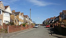
St. Julians ( Welsh : Sain Silian ) is a neighborhood ( Ward and Community ) of the city of Newport in the south of Wales .
Location, infrastructure and population
St. Julians is about halfway between old town Newport and Caerleon . The town is bounded by the River Usk to the north and west, the Beechwood district to the east and Victoria / Maindee to the south .
The district has 8,675 inhabitants ( 2011 census ) on an area of 1.94 km². The administrative and geographical boundaries of the place do not exactly match, however, the eastern part of St. Julians already belongs administratively to Beechwood.
In the north-west of the district, in the bend of the Usk, is the extensive Glebeland park , a renatured landfill , which is, however, polluted by chemical waste.
In the district is the St Julian's School , a large secondary school. There is an Anglican-Welsh , a Methodist and a Baptist church.
The M4 motorway and the Welsh-Marches railway line run through the area of the district.
history
The place is named after the martyr Julius von Caerleon , whose name is also written Julian . Until the late Middle Ages, there was a church here on the road between the towns of Newport and Caerleon on the banks of the river, said to be where the martyr's bones were kept. The church and its surroundings belonged to the Goldcliff Priory ; St. Julians is mentioned in the Book of Llandaff .
At the end of the 15th century, Sir George Herbert had the remains of the church demolished and an estate ( St. Julian's House ) built in its place , which he made into his family residence. He founded the Herberts of St. Julians line , which would last for four generations. George Herbert was the third son of Black William Herbert, 1st Earl of Pembroke , who had ruled large parts of southern Wales for the House of York during the Wars of the Roses .
Sir George's son, Sir Walter Herbert († 1550/51), was High Sheriff of Monmouthshire , Justice of the Peace and Member of Parliament . His eldest son William († 1567) succeeded him in these offices. The family gained wealth not only through offices and property, but especially through maritime trade. The second son George († 1580) was an important seafarer and trader.
Williams son of the same name († 1593) was involved in the Plantation of Munster in Ireland . Since he only had one surviving daughter, he made her sole heir, on the condition that she would marry a member of the Herbert family. She married Edward Herbert of Chirbury , who became the new lord of St. Julians.
The property remained in the possession of their descendants, the Barons of Chirbury , who hardly lived there. After this line became extinct, St. Julian's House changed hands several times, was rebuilt, eventually used as a farm and increasingly fell into disrepair.
In the late 19th and early 20th centuries, the city of Newport grew north and St. Julian's was built as a typical British housing estate of the time. In the 1950s, the place was significantly expanded with the construction of the St Julians Estate , a residential area consisting of 960 houses and apartments.
Individual evidence
- ^ Office for National Statistics : Area: St. Julians (Parish), Population Density, 2011
- ^ Friends of the Earth Chepstow : Glebelands Alliance - About the Glebelands
- ↑ Gwent Local History, caerleon.net: The Herberts of St. Julians , by Mrs Eija Kennerley, 1973 , St. Julian's House, Newport , by MJ Waterhouse and HB Waterhouse, 1974 and St. Julian's Church, Newport , by Mrs. Olive M. Ellis, 1975 ; as well as tudorplace: HERBERT FAMILY St. JULIAN LINE and newportpast.com: St. Julian's House , Porch of St. Julian's House
- ↑ newportpast.com: Chronology of the 20th century
Web links
Coordinates: 51 ° 36 ′ N , 2 ° 59 ′ W

