M4 motorway
| M4 motorway in the UK | |||||||||||||||||||||||||||||||||||||||||||||||||||||||||||||||||||||||||||||||||||||||||||||||||||||||||||||||||||||||||||||||||||||||||||||||||||||||||||||||||||||||||||||||||||||||||||||||||||||||||||||||||||||||||||||||||||||||||||||||||||||||

|
|||||||||||||||||||||||||||||||||||||||||||||||||||||||||||||||||||||||||||||||||||||||||||||||||||||||||||||||||||||||||||||||||||||||||||||||||||||||||||||||||||||||||||||||||||||||||||||||||||||||||||||||||||||||||||||||||||||||||||||||||||||||
| |
|||||||||||||||||||||||||||||||||||||||||||||||||||||||||||||||||||||||||||||||||||||||||||||||||||||||||||||||||||||||||||||||||||||||||||||||||||||||||||||||||||||||||||||||||||||||||||||||||||||||||||||||||||||||||||||||||||||||||||||||||||||||
| map | |||||||||||||||||||||||||||||||||||||||||||||||||||||||||||||||||||||||||||||||||||||||||||||||||||||||||||||||||||||||||||||||||||||||||||||||||||||||||||||||||||||||||||||||||||||||||||||||||||||||||||||||||||||||||||||||||||||||||||||||||||||||
| Basic data | |||||||||||||||||||||||||||||||||||||||||||||||||||||||||||||||||||||||||||||||||||||||||||||||||||||||||||||||||||||||||||||||||||||||||||||||||||||||||||||||||||||||||||||||||||||||||||||||||||||||||||||||||||||||||||||||||||||||||||||||||||||||
| Operator: | Highways Agency (England) | ||||||||||||||||||||||||||||||||||||||||||||||||||||||||||||||||||||||||||||||||||||||||||||||||||||||||||||||||||||||||||||||||||||||||||||||||||||||||||||||||||||||||||||||||||||||||||||||||||||||||||||||||||||||||||||||||||||||||||||||||||||||
| further operator: | Welsh Government (Wales) | ||||||||||||||||||||||||||||||||||||||||||||||||||||||||||||||||||||||||||||||||||||||||||||||||||||||||||||||||||||||||||||||||||||||||||||||||||||||||||||||||||||||||||||||||||||||||||||||||||||||||||||||||||||||||||||||||||||||||||||||||||||||
| Overall length: | 305.0 km (189.5 mi ) | ||||||||||||||||||||||||||||||||||||||||||||||||||||||||||||||||||||||||||||||||||||||||||||||||||||||||||||||||||||||||||||||||||||||||||||||||||||||||||||||||||||||||||||||||||||||||||||||||||||||||||||||||||||||||||||||||||||||||||||||||||||||
| The M4 at AS 14 | |||||||||||||||||||||||||||||||||||||||||||||||||||||||||||||||||||||||||||||||||||||||||||||||||||||||||||||||||||||||||||||||||||||||||||||||||||||||||||||||||||||||||||||||||||||||||||||||||||||||||||||||||||||||||||||||||||||||||||||||||||||||
|
Course of the road
|
|||||||||||||||||||||||||||||||||||||||||||||||||||||||||||||||||||||||||||||||||||||||||||||||||||||||||||||||||||||||||||||||||||||||||||||||||||||||||||||||||||||||||||||||||||||||||||||||||||||||||||||||||||||||||||||||||||||||||||||||||||||||

The M4 motorway ( English for 'M4 motorway') is a motorway in Great Britain that connects London with Wales . It is part of the unsigned Europastraße 30 . It begins in West London ( Chiswick ), and important places along the route are Reading , Swindon , Bristol , Newport , Cardiff , Bridgend , Swansea and Llanelli . Originally this motorway was called "London-South Wales Motorway" and replaces the old A-road A4 (London-Bristol) on the English side.
history
A new road on the London – South Wales route was planned by the British Ministry of Transport in the 1950s as one of the first projects in the post-war period. Construction began with the Maidenhead bypass (west of London), which opened in 1961 and was numbered A4 (M) before opening. In 1965 the London – Maidenhead line was completed, along with the overpass in Chiswick, which had already opened in 1959.
In the meantime, construction had started in the area from Bristol to Newport. The heart of this route is the Severn Bridge , which is now on the M48 Motorway ; Junctions 18 (at Yate ) to 23 (at Magor in Wales) were opened at the end of 1966. Further west, however, the first ever motorway in Wales was opened earlier in 1966, the old A48 (M) in Port Talbot , which is now part of the M4. In 1967 the Newport bypass was completed, the west end of which at Tredegar Park was previously planned as the end point of the M4; after the establishment of the Welsh Office in 1964, plans for an extension further west were worked out.
In 1971, all missing lines in England, i.e. the gap between Maidenhead and Yate , were completed and, with a few exceptions, the old bypasses were extended to three lanes in each direction. In Wales, the focus was on the construction of various bypasses, beginning with the Morriston bypass near Swansea in 1972 (originally planned as the A48 (M)). In 1977, other large parts were opened, including the East approach from Cardiff, the Cardiff – Bridgend, Pyle – Port Talbot and Morriston – Portarddulais routes. In 1980 Cardiff and Bridgend bypasses followed. Only the six-mile stretch between Port Talbot and Morriston was not realized for many years due to the bog bottom and the navigable River Neath . The gap was not closed until 1994.
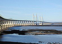
The last change took place in 1996 with the opening of the new cable-stayed bridge over the Severn between England and Wales, the Second Severn Crossing . The old route was then renamed M48.
In 2010, expansion work from four to six lanes on the Cardiff bypass was completed.
Others
In 1999 a bus lane was set up in a pilot project on a short section in London. In 2010 the project was temporarily terminated and the previous state was restored. The experiment was repeated for the 2012 Olympic Games .
It was planned to build a new highway called the M4 Toll south of Newport. As the name suggests, it should be a private motorway similar to the M6 Toll Motorway near Birmingham. This new motorway should relieve the M4 at Newport, especially the bottleneck around the Brynglas tunnel, which cannot be expanded. The planned cost was originally £ 350m. However, after a cost increase to £ 1bn, the Welsh government decided in 2009 to abandon the project.
Individual evidence
- ^ Pathetic Motorways: A4 (M) Maidenhead Bypass
- ^ The Motorway Archive. M4 in Wales ( Memento from January 24, 2015 in the Internet Archive )
- ↑ 'Don't scrap M4 relief road' call, BBC.co.uk, accessed November 8, 2011


