M25 motorway
| M25 motorway in the UK | ||||||||||||||||||||||||||||||||||||||||||||||||||||||||||||||||||||||||||||||||||||||||||||||||||||||||||||||||||||||||||||||||||||||||||||||||||||||||||||||||||||||||||||
|
|
||||||||||||||||||||||||||||||||||||||||||||||||||||||||||||||||||||||||||||||||||||||||||||||||||||||||||||||||||||||||||||||||||||||||||||||||||||||||||||||||||||||||||||
| map | ||||||||||||||||||||||||||||||||||||||||||||||||||||||||||||||||||||||||||||||||||||||||||||||||||||||||||||||||||||||||||||||||||||||||||||||||||||||||||||||||||||||||||||
| Basic data | ||||||||||||||||||||||||||||||||||||||||||||||||||||||||||||||||||||||||||||||||||||||||||||||||||||||||||||||||||||||||||||||||||||||||||||||||||||||||||||||||||||||||||||
| Operator: | Highways Agency | |||||||||||||||||||||||||||||||||||||||||||||||||||||||||||||||||||||||||||||||||||||||||||||||||||||||||||||||||||||||||||||||||||||||||||||||||||||||||||||||||||||||||||
| Overall length: | 188 km (116.8 mi ) | |||||||||||||||||||||||||||||||||||||||||||||||||||||||||||||||||||||||||||||||||||||||||||||||||||||||||||||||||||||||||||||||||||||||||||||||||||||||||||||||||||||||||||
| Development condition: | mostly eight lanes | |||||||||||||||||||||||||||||||||||||||||||||||||||||||||||||||||||||||||||||||||||||||||||||||||||||||||||||||||||||||||||||||||||||||||||||||||||||||||||||||||||||||||||
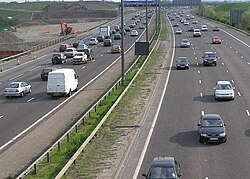
| The M25 near Heathrow Airport | ||||||||||||||||||||||||||||||||||||||||||||||||||||||||||||||||||||||||||||||||||||||||||||||||||||||||||||||||||||||||||||||||||||||||||||||||||||||||||||||||||||||||||||
|
Course of the road
|
||||||||||||||||||||||||||||||||||||||||||||||||||||||||||||||||||||||||||||||||||||||||||||||||||||||||||||||||||||||||||||||||||||||||||||||||||||||||||||||||||||||||||||
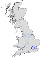
The M25 motorway ( English for "Motorway M25") is a motorway in England . It runs in a ring around the British capital London , is 188 kilometers long and is also known as the "London Orbital". It is the second longest ring road in Europe after the Berliner Ring .
description
The M25 has eight lanes on most of the route , with four lanes in each direction . In November 2005, the M25 was expanded to ten lanes between junctions 12 and 14 and to twelve lanes between junctions 14 and 15. The most heavily used section is between junction 13 and 14 near Heathrow Airport , where an average of 196,000 vehicles per day were counted in 2003.
From a legal point of view, the M25 is not classified as a motorway throughout. The toll road crossing over and under the Thames east of London between Thurrock and Dartford is designated A282 . This section, known as the Dartford Crossing , was classified as a main road in order to enable vehicles to cross the route that are not permitted to use motorways. Otherwise they would have to make a long detour via Woolwich .
The road runs through several counties: Junctions 1 to 5 are in Kent , 6 to 14 in Surrey , 15 and 16 in Buckinghamshire , 17 to 24 in Hertfordshire , 25 and 29 in Greater London, and 26 to 28, 30 and 31 in Essex . Police work is carried out by a joint task force consisting of units from the affected police districts. These include the London Metropolitan Police , Thames Valley Police, Essex Police, Kent Police, Hertfordshire Constabulary and Surrey Police.
history
Initial traffic plans between 1937 and 1944 envisaged up to five ring roads around London. Concrete plans for the London Ringways Plan in the 1960s took up these plans with four motorway rings . Due to massive protests against the destruction of living space, this plan was dropped in 1973 and only implemented in a reduced form. Parts of the two planned outer rings 3 and 4 were finally closed to form today's M25.
The ring was built in steps between 1975 and 1985, but not in one piece, but in smaller sections, such as B. between Dartford and Swanley (junctions 1 to 3) and between Potters Bar and Waltham Cross, which were later connected to each other. A separate planning right was required for each section, which had to be justified individually. In the maps of that time, the sections were referred to as "M16". The change to M25 was made before completion.
In October 1986 the M25 was opened with a ceremony by then Prime Minister Margaret Thatcher . The opening took place between junction 22 “London Colney” and 23 “ South Mimms ”.
The total cost of construction was £ 631.9 million (€ 919.2 million). This does not include the cost of land purchase or expansion and maintenance work.
Web links
- CBRD Motorway Database - M25
- The Motorway Archives - M25. Archived from the original on July 20, 2009 ; accessed on May 9, 2017 .
- Elsemarie Maletzke: The Ring of Terror. In: Die Zeit from March 1, 2012 No. 10
Coordinates: 51 ° 30 ′ N , 0 ° 8 ′ W


