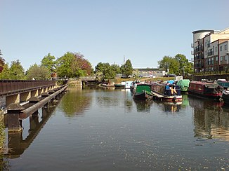
River Lea (Thames)
|
River Lea River Lee |
||
|
Lea at Hertford |
||
| Data | ||
| location | England | |
| River system | Thames | |
| Drain over | Thames → North Sea | |
| source | Leagrave Park at Luton 51 ° 54 ′ 37 ″ N , 0 ° 27 ′ 40 ″ W. |
|
| Source height | 115 m ASL | |
| muzzle | in Leamouth ( Tower Hamlets ) in the Thames Coordinates: 51 ° 30 ′ 26 " N , 0 ° 0 ′ 33" E 51 ° 30 ′ 26 " N , 0 ° 0 ′ 33" E |
|
| Mouth height | 0 m ASL | |
| Height difference | 115 m | |
| Bottom slope | 1.7 ‰ | |
| length | 68 km | |
| Left tributaries |
River Mimram , River Beane , River Rib , River Ash , Standstead Mill Stream , River Stort , Tollhouse Stream , The Ching , Coppermill Stream , City Mill River , Three Mills Wall River , Prescott Channel , Waterworks River , Channelsea River |
|
| Right tributaries |
Essendon Brook , Bayford Brook , River Lynch , Small River Lea , Pymme's Brook , Hertford Union Canal , Limehouse Cut |
|
| Big cities | Luton | |
| Medium-sized cities | Hertford , Cheshunt | |
The River Lea or River Lee (both names are in use) is a river in England . It rises near Luton in the Chiltern Hills and then flows eastwards first. East of Hertford , the river changes direction and flows further south towards London , where it flows into the Thames . The estuary, an approximately four kilometers long, tide-dependent estuary , is also called Bow Creek .
The winding course of the Lea was made navigable by Lea Navigation under a law of 1767 . This making navigable partly uses the natural course, which has been straightened and expanded itself, or a shipping canal built parallel to the original course. The river can be traveled by traditional narrowboats from its mouth to the center of Hertford . Today this is done for recreational purposes, while the original expansion took place for goods transport. It is connected to the Grand Union Canal and thus to the rest of England's inland waterway network via the Thames or Regent's Canal and Paddington Arm .
The tributaries Channelsea River , City Mill River , Prescott Channel , Three Mills Wall River and Waterworks River form the group of Bow Back Rivers .
The spelling Lea is in use west of Hertford, while both forms (Lea or Lee) are used in the further course up to the confluence.
The river has its source west of Luton and then flows through (or along) Luton, Harpenden , Welwyn Garden City , Hertford, Ware , Hoddesdon , Cheshunt , Edmonton , Tottenham , Upper Clapton , Hackney Wick , Stratford , Bromley-by-Bow , Canning Town and finally Leamouth , where it flows into the Thames.
The river in England is not to be confused with the River Lee in County Cork in Ireland and the Lea in northern Spain.
Web links
Individual evidence
- ↑ Lee Navigation on the UK Canal and River Trust pages , accessed February 28, 2018
