Nienover urban desert
The urban desert of Nienover was a town-like settlement in front of Nienover Castle in what is now Nienover in Solling in Lower Saxony . About 500 to 700 people lived in the settlement founded around 1180. It was fortified by a rampart and moat. In an attack around 1270, the settlement was destroyed and not rebuilt.
description
The settlement was on the plateau of a 200 m above sea level. NHN high ridge and was designed as a three- road system that ran to Nienover Castle. The dimensions of the settlement were about 300 × 500 meters. It had an interior area of eight hectares. On the north and west sides, the city was secured by a double rampart and moat around 40 meters wide. The settlement site was located at a crossroads of the ways to Castle Gieselwerder , the castle Dassel in and on the old military road for temporary storage King Sohlingen went off.
The houses stood along the streets and to the edge. There were houses of different sizes, which is taken as an indication of a socially structured population, unlike in a village. The houses had stone and wooden cellars. The wooden buildings were in the stone cellar column design placed. Due to the small wall thickness of the cellars of 50 to 70 cm, the houses are likely to have been one to two storeys high. The basement sizes varied between 10 and 20 m². The houses were up to 10 meters wide and sometimes over 20 meters long. The size of the property was between 9 to 20 meters street width and up to 40 meters deep.
The pottery that was found gave evidence of an urban settlement and the connection between the place and the Counts of Dassel. Ceramic products were found from the Reinhardswald , in which the counts had rights and possessions. There were also vessels from the pottery at Solling , such as Fredelsloh , where the Counts of Dassel had their main property. Siegburger stoneware was also found . Metal processing of iron took place in the settlement, as indicated by finds of slag and furnaces. Several wells of shallow depth were found. Shards of high medieval pottery found in it were used for dating.
In economic terms, the settlement is likely to have served as the central location of the county of Nienover and as a marketplace. The basis of the settlement is likely to have been brewing, mining, processing and trading in sandstone, wood and glass. Lead weights and the remains of folding carts indicated trade.
history
On the site in front of Nienover Castle, the Counts of Dassel founded a settlement around 1180, which, due to its size and later documents, was a town. The Counts von Dassel had the forest cleared for the construction of the houses and for the agricultural use of the land . Since this was partially not covered by their rights, the counts had to pass to Bishop Bernhard III in 1210 . Make atonement. Around 1220 Nienover fell victim to a fire, probably as a result of a feud, but was immediately rebuilt.
At one point in time between 1269 and 1274, Nienover was attacked from the north. There was a battle with the use of numerous crossbow bolts and arrows. The wooden construction turned out to be disadvantageous, so that the entire place burned down, only the castle remained usable in the following centuries. At the same time, the general economic conditions had deteriorated significantly, as the protective counts withdrew from the southern area through the sale of Schartenberg Castle . Therefore the houses were not rebuilt.
The last person to be documented in the following decades was the pastor. No documents are available about the attackers, for reasons of power politics Albrecht the Tall One comes into question as a mastermind.
On February 15, 1303, Count Simon von Dassel sold the castle and county of Nienover with the associated rights and possessions to Duke Albrecht the Feisten as sovereign of the Principality of Göttingen . With that the place came into the possession of the Guelphs.
Desolation

The destroyed city was used as arable land and pasture after it fell into desolation . Its existence was forgotten, so that it was only rediscovered through archaeological research from 1996 onwards. The desert fall is a consequence of the change of the high medieval state rule and fundamental for the understanding of today's southern borders of Lower Saxony.
The city wall , cellar, remains of the streets of the three-street system and other evidence of the medieval settlement of Nienover have been preserved in the ground . The complex is a rare example of urban desertification and therefore an archaeological ground monument of great scientific and tourist interest.
Research history
From 1996 the site and building relics were archaeologically examined under the direction of Hans-Georg Stephan . Up until 2004 there were annual excavation campaigns. After the initial successes, the investigations were expanded to include the Winnefeld desert , the Schmeessen desert and the Waldglashütte am Lakenborn . The prospections were carried out using ground penetrating radar , geobotany , geoecology and aerial archeology . An international team of scientists was found appropriate to the importance of the site.
After the castle was sold in private hands in 2005, the new owner prohibited further excavations on the site. All further research on questions of dating, access roads and gates in the wall as well as the remaining houses and the search for a possible church location are not possible for an indefinite period. With the construction of a riding arena for the stud farm located in the castle, an area that has hardly been used for centuries was built over. In accordance with a stipulation of the Northeim district, no excavation pit was dug so that the archaeological soil exploration can be continued later. At the mediation of the Northeim district, a small area on the northern edge was made available for the reconstruction of a medieval house.
Partial reconstruction

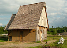
In 2007, an urban half-timbered house from around 1230 was reconstructed by a building historian on a scientific basis over the excavated cellar of a house near the street . The basic structure takes up elements of the hall building . Historical techniques were used in construction technology. Since it is the former bakery, it is provided with a stone oven, according to the time without a chimney. It also has a large gate to the entrance of the harvest cart. The attic of the clapboard-clad building is spacious. The basement starts with the excavated original foundations. The property is fenced in by a wicker fence made of willow .
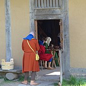
Living history events take place on the property . Re- enactments of medieval life scenes and musical performances based on historical fragments are presented. Expert supervision and advice in terms of experimental archeology are provided by Petra Lönne for the Northeim district.
literature
- Hans-Georg Stephan : City of Nienover - downfall in fire in: Archeology in Lower Saxony , 2003, pp. 51–55
- Hans-Georg Stephan, Ralf Mahytka, Radoslav Myszka, Matthias Zirm, Hans-Rudolf Bork, Arno Beyer: Archaeological-ecological research on landscape, settlement and economic history in Solling in 2006 in: Göttinger Jahrbuch 55, 2007, p. 239ff
- Hans-Georg Stephan, Sonja König, Thomas Küntzel: The urban desert Nienover in Solling In: Mamoun Fansa , Frank Both, Henning Haßmann (editor): Archeology | Land | Lower Saxony. 400,000 years of history. State Museum for Nature and Man, Oldenburg 2004. Pages 637–640.
- Thomas Küntzel: City and Border - The Landwehr of the Nienover urban desert in the context of southern Lower Saxony. In: Archaeologia historica. Volume 29, 2004, pp. 167-191.
Web links
- Description of the urban desert at Martin Luther University Halle-Wittenberg
- Lost city of Nienover
- Reconstruction drawing of the medieval Nienover Castle with the town settlement
- The urban desert of Nienover in Solling
- Excavation of the medieval city of Nienover 1996-2006
- Reconstruction of a medieval house in 2007
- Medieval house Nienover
- 3 D video film of the exterior and interior of the medieval house in Nienover
- Flyer Medieval Center Nienover at the medieval half-timbered house of the urban desert (pdf, 1.8 MB)
- When the Guelph troops came to the sinking of Nienover in the Süddeutsche Zeitung on May 17, 2010
Individual evidence
- ↑ Erhard Kühlhorn: The medieval desertions in southern Lower Saxony, Volume 34, Part 2, 1994, p. 516
- ↑ Hans-Georg Stephan: Stadt Nienover - Untergang im Feuer, in: Archäologie in Niedersachsen 6, 2003, p. 51ff
- ↑ Helmut Jäger, Erhard Kühlhorn: Historical-regional excursion map of Lower Saxony: sheet Osterode am Harz, 1996, p. 85
- ↑ Walter Junge: Chronicle of the spot Bodenfelde . Bodenfelde 1983, p. 41
- ↑ Hans-Georg Stephan: "Nienover - a submerged medieval city in Solling", in: Archäologie in Niedersachsen 1 (1998), p. 97ff
- ↑ International team of archaeologists excavates medieval city
- ^ Submerged city of Nienover on n-tv.de from March 31, 2009
Coordinates: 51 ° 40 ′ 55.5 ″ N , 9 ° 31 ′ 9.7 ″ E

