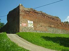
Stare Drawsko
Stare Drawsko ( German Alt Draheim ) is a village in the West Pomeranian Voivodeship in Poland . It belongs to the Gmina Czaplinek (Tempelburg community) in the Powiat Drawski (Dramburger Kreis) .
Geographical location
The village is located in Western Pomerania about 100 kilometers east of Stettin on an isthmus between the Drawsko ( Dratzigsee ) in the west and the Żerdno (also Jezioro Srebrne , German Sarebensee ) in the east. Woiwodschaftsstraße 163 , whose course corresponds to the former Reichsstraße 124 , runs through the town in a north-south direction . The town of Czaplinek ( Tempelburg ) is located on this road about 5 kilometers south and the village of Kluczewo ( Klaushagen ) about 5 kilometers north . On the opposite, eastern bank of the Żerdno is the village Nowe Drawsko ( Neu Draheim ).
history
The village goes back to Draheim Castle , which the Order of St. John had built around 1355 and which was the administrative center of the Starostei Draheim from the 15th century to 1731 .
The beginning of the village can be deduced from the income registers ("lustration") of the Starostei, which at that time belonged to the Kingdom of Poland: The village does not yet appear in the lustration of 1565. In the lustration of 1628/1632 a "village near Draheimer Schloss" with eight small farmers ("gardeners") is mentioned.
As part of the Starostei Draheim, the village came into the possession of Brandenburg-Prussia in 1668 and from 1772 also formally belonged to the Prussian state territory.
In Ludwig Wilhelm Brüggemann's detailed description of the current state of the Royal Prussian Duchy of Western and Western Pomerania from 1784, the village "Draheim" with 34 households ("fire places") is mentioned.
As part of the administrative restructuring in Prussia, the area of the former Starostei was incorporated into the Neustettin district within the province of Pomerania in 1817 , in which the village of Alt Draheim was a rural community until 1945. The residential areas Adlig Draheim, Eichwerder, Kalkwerder, Karlsberg, Mittelbusch and Ziegelei belonged to the rural community (status 1939).
Development of the population
- 1925: 240
- 1933: 386
- 1939: 367
Attractions
- Ruins of Draheim Castle
- Church, built in 1861 as a Protestant church in neo-Gothic style. Base and walls made of split boulders, other building elements made of bricks and shaped stones.
literature
- Ernst Bahr, Roderich Schmidt : Alt Draheim . In: Helge bei der Wieden , Roderich Schmidt (Hrsg.): Handbook of the historical sites of Germany . Volume 12: Mecklenburg / Pomerania (= Kröner's pocket edition . Volume 315). Kröner, Stuttgart 1996, ISBN 3-520-31501-7 , pp. 147-148.
- Johannes Hinz : Pomerania. Signpost through an unforgettable country. Flechsig-Buchvertrieb, Würzburg 2002, ISBN 3-88189-439-X , p. 31.
Web links
Footnotes
- ^ Ernst Bahr: Die Starostei Draheim between 1565 and 1632. In: Baltic studies . Volume 57 NF, 1971, ISSN 0067-3099 , p. 33.
- ↑ Ludwig Wilhelm Brüggemann : Detailed description of the current state of the Royal Prussian Duchy of Western and Western Pomerania. 2nd part, 2nd volume. Stettin 1784, p. 730.
- ^ A b c Michael Rademacher: German administrative history from the unification of the empire in 1871 to the reunification in 1990. neustettin.html. (Online material for the dissertation, Osnabrück 2006).
- ^ Haik Thomas Porada , Michael Lissok: The former Starostei Draheim and the city of Tempelburg. In: Pomerania. Journal of Culture and History. Issue 2/2002, ISSN 0032-4167 , p. 8.
Coordinates: 53 ° 36 ' N , 16 ° 12' E


