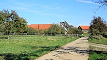
Steinenbach (Ruppertshofen)
|
Steinenbach
Ruppertshofen municipality
Coordinates: 48 ° 53 ′ 48 ″ N , 9 ° 49 ′ 24 ″ E
|
|
|---|---|
| Height : | 510-515 m above sea level NN |
| Residents : | 30th |
| Postal code : | 73577 |
| Area code : | 07176 |
Steinenbach is a hamlet in the municipality of Ruppertshofen in the Ostalb district in eastern Baden-Württemberg . With 30 inhabitants, it is the smallest of the Ruppertshofen suburbs.
geography
Steinenberg is about one and a half kilometers north of the eponymous village and municipality seat Ruppertshofen, like this one on the western edge of the mountain range of the Frickenhofer Höhe that extends from Seifertshofen in the north to Täferrot in the valley of the Lein collecting these rivers to the south , which on this side of the valley from Auerbach and lower "Gschwender" red , bordered in the east by the Götzenbach valley cut . The Brühlbach rises on the outskirts and has carved a steep blade for itself in a short westward run to the Auerbach . On the ridge of the plateau, the K 3328 running in its direction passes the eastern edge of the hamlet, which has almost a dozen in house locations at heights of 510 to 515 m above sea level. NN stand. In the open area around Steinenbach there are almost only fields on the flat plateau, in the soft area around the village there are orchards and meadows on the still unforested upper valley slopes.
history
Around 800 AD, free farmers settled around Steinenbach. They were followed by farmers from Weibelhubige in the 12th century. The free farmers went into the feudal dependency of the city of Gmünd and until 1414 in that of the Limpurg taverns .
At the end of 1944, at the end of the Second World War , the Nazi construction team Organization Todt set up a large construction site on the level between Seifertshofen , Steinenbach, Helpertshofen and Kemnaten , with the aim of building a 2.5 km long concrete runway for jet fighters of the Messerschmitt Me 262 type to build. Around 600 workers, mostly prisoners of war , were deployed, barracks were built in the surrounding villages and wooded areas were cut down. Due to the advance of the US Army, construction work was canceled on April 18, 1945.
Economy and Infrastructure
Apart from agriculture, there is no industry in the hamlet.
traffic
On the ridge of the plateau, the K 3328, which runs from the L 1080 in the north near Seifertshofen via the Ziegelhütte and then Ruppertshofen to Täferrot in the south, passes the eastern edge of the hamlet and opens up this; Via it, the main town of the municipality is less than 2.5 km away. An OstalbMobil line connects the town with Schwäbisch Gmünd , and there is a connection to Gaildorf via Frickenhofen .
swell
- ↑ Aloys Schymura: Ruppertshofen through the ages . Ruppertshofen municipality, 1995.
- ^ Walter Hees: The Americans are coming ... Verlag Manfred Hennecke, Remshalden 2006, ISBN 3-927981-84-2 , p. 133 ff .
