Steingraben (Pinzberg)
|
Stone trench
community Pinzberg
Coordinates: 49 ° 41 ′ 18 ″ N , 11 ° 8 ′ 26 ″ E
|
|
|---|---|
| Height : | 309 (306-312) m above sea level NHN |
| Residents : | 2 (1987) |
| Postal code : | 91361 |
| Area code : | 09191 |
|
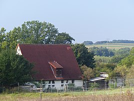
The Pinzberg district of Steingraben
|
|
Steingraben is a Franconian wasteland that belongs to Pinzberg .
geography
The in Erlanger Albvorland preferred solitude is one of five officially designated community parts of the Upper Franconian municipality Pinzberg. Steingraben is located about three kilometers east-southeast of the center of Pinzberg at an altitude of 309 m above sea level. NHN .
history
Until the communal territorial reform carried out in Bavaria in the 1970s , Steingraben was part of the municipality of Dobenreuth , and on May 1, 1978 it was incorporated into the municipality of Pinzberg. In 1987 Steingraben had two residents.
traffic
The connection to the road network is a spur road that branches off from the state road St 2236 , which passes southwest of the town . The wasteland is not served by public transport , the next stop of the VGN bus line 223 is in Kunreuth and the closest train stop in Gosberg on the Wiesenttalbahn .
literature
- Federal Statistical Office (Hrsg.): Historical municipality register for the Federal Republic of Germany. Name, border and key number changes in municipalities, counties and administrative districts from May 27, 1970 to December 31, 1982 . W. Kohlhammer, Stuttgart / Mainz 1983, ISBN 3-17-003263-1 .
Web links
- Bavarian authorities' guide for Steingraben , accessed on November 6, 2019
- Steingraben in the BayernAtlas , accessed on November 6, 2019
- Stone digging on historical map , accessed November 6, 2019
- Stone trench in the Topographia Franconiae of the University of Würzburg , accessed on November 6, 2019.
Individual evidence
- ↑ a b Bavarian State Office for Statistics and Data Processing (Ed.): Official local directory for Bavaria, territorial status: May 25, 1987 . Issue 450 of the articles on Bavaria's statistics. Munich November 1991, DNB 94240937X , p. 303 ( digitized version ). Retrieved November 6, 2019
- ↑ Steingraben in the local database of the Bavarian State Library Online . Bayerische Staatsbibliothek, accessed on November 6, 2019.
- ↑ Geographical location of Steingraben in the Bayern Atlas , accessed on November 6, 2019
- ^ Federal Statistical Office (ed.): Historical municipality directory for the Federal Republic of Germany. Name, border and key number changes in municipalities, counties and administrative districts from May 27, 1970 to December 31, 1982 . W. Kohlhammer, Stuttgart / Mainz 1983, ISBN 3-17-003263-1 , p. 684 .
