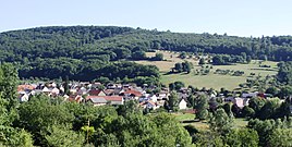
Steinheim (Rosport-Mompach)
|
Steinheim ( German ) Steenem ( lux. ) Steinheim ( French ) Community Rosport-Mompach
|
||
|---|---|---|
| Coordinates : | 49 ° 49 ′ N , 6 ° 29 ′ E | |
| Height : | 155 m | |
| Residents : | 667 (Jan. 2, 2018) | |
| Postcodes : | 6586, 6587 | |
|
Location of Steinheim in Luxembourg
|
||
|
Steinheim
|
||
Steinheim ( lux . : Steenem ) is a district of the municipality of Rosport-Mompach in the Grand Duchy of Luxembourg .
location
Steinheim is located in the far north of the municipality of Rosport-Mompach on the banks of the Sauer and thus directly on the state border between Luxembourg and Germany . Neighboring towns are Minden and Edingen on the German side and Rosport on the Luxembourg side. National road 10 runs through the village.
history
Steinheim is an ancient settlement, probably of Celtic origin, built on pile dwellings in the Sauerniederung. The name Steinheim first appeared in 704, when Irmina von Oeren Willibrord gave the Villa Steinheim (= Staneheim) an der Sauer as a gift. Thus Steinheim belonged to the Echternach Abbey for a long time.
Steinheim belonged to the municipality of Rosport until December 31, 2017 and since January 1, 2018 to the new municipality of Rosport-Mompach, which was created from the merger of the two municipalities of Rosport and Mompach.
church
The Catholic parish church of St. Mariä Himmelfahrt (Steinheim) is located in the village , a building from the 18th century.
Web links
Individual evidence
- ^ Nombre d'habitants. In: Website of the municipality of Rosport. Retrieved May 1, 2018 .


