Buschberg
| Buschberg | ||
|---|---|---|
|
Buschberg with the civil aircraft radar system |
||
| height | 491 m above sea level A. | |
| location | Gnadendorf , Lower Austria | |
| Mountains | Quieter mountains | |
| Dominance | 35.1 km → Windischalm | |
| Notch height | 250 m ↓ east of Schalladorf | |
| Coordinates | 48 ° 34 '31 " N , 16 ° 23' 46" E | |
|
|
||
| rock | Waschbergzone (limestone) | |
The Buschberg is located in the Mistelbach district , is the highest elevation in the Leiser Berge and also in the Weinviertel in Lower Austria . It is 491 m above sea level. A. The secondary peak is the Steinmandl ( 480 m ⊙ ).
Location and landscape
On a clear day, the cross, which was erected on the plateau of the medieval Hausberg, overlooks the entire Vienna basin up to the 100 km south towering peaks of the Limestone Alps , especially the Viennese local mountains Schneeberg and Rax .
History, development and development

The name Buschberg does not come from today's 'Busch', but from the Old High German pusk 'bump'. This means the arrangement with the other mountains in the area.
The area around the Buschberg was settled at an early stage, as archaeological finds show. During excavations, for example, a Roman house was found which is believed to have been built by the Romans for a German , as the area is north of the Danube Limes and was therefore never Roman. The westernmost summit, which offers the best view, is surrounded by a prehistoric defensive rampart .
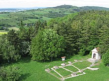
At 485 m above sea level A. high southern pre-summit of the Buschberg, today located in the municipality of Niederleis , a small, fortified house mountain was built in the Middle Ages , which was probably used as a control room. The dome was separated from the main stick by an incision and a 5 to 8 meter high oval cone was carved out. This carries a platform measuring around 24 by 9 meters. In the middle height of the conical mantle you can still see a step that carried the former battlement. The base of the cone was protected by a surrounding wall. In the population, the facility is called "Simperlberg" and "Schwedenschanze". It is possible that the knoll was actually used as a military observation point during the Swedish War. Today the slope of the local mountain houses a grass steppe which is interesting from a nature conservation point of view , which is assigned to the Stipo-Festucetum valesiacae vegetation association .
The Buschberghütte stands near the summit , at only 484 m the lowest hut in the Alpine Club . At the main summit is the air traffic control radar of the Austro Control for monitoring civil aviation in the eastern half of Austria. The tower with the large radome can be seen from afar and is almost 40 m high. A radar station of the Austrian Armed Forces , which is part of the Goldhaube military air surveillance system, stands a little further to the east on the Steinmandl sub-peak . Since 2009 it has been a phased array antenna of the type RAT-31DLS , which replaced a system of the type RAT-31S installed in 1985 . It has a range of 500 km with 360 ° all-round coverage and can capture transponder signals from aircraft up to 450 km away.
Today the Leiser Berge nature park with its special vegetation is located around the Buschberg .
Individual evidence
- ↑ Hans P. Schad'n: The local mountains and related fortifications in Lower Austria. In: Prehistoric Research 3; Vienna 1953.
- ^ Wolfgang Willner: Pannonian steppe grasslands in Austria. In: Henryk Baumbach, Stephan Pfützenreuter (Hrsg.): Steppe habitats in Europe: Endangerment, conservation measures and protection. Thuringian Ministry of Agriculture, Forests, Environment and Nature Conservation (TMLFUN), Erfurt 2013, ISBN 978-3-00-044248-3 , p. 155. (PDF; 549 kB)
Web links
- Fixed radar stations (ORS) of the Goldhaube air surveillance at www.airpower.at
- Conversion to RAT-31DL-Radar Bundesheer: Airspace surveillance in the 2nd Republic


