
Stevia (Dolomites)
| Stevia | ||
|---|---|---|
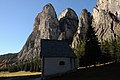
![The northwestern stevia walls and on the right in the background the Sella group viewed from the Aschgleralm. The Pela de Vit divides from left to right in the E, Central and SW summit [1]](https://de.wikipedia.org/wiki/Datei:Stevia_Gr%C3%B6den-1.jpg) The northwestern stevia walls and on the right in the background the Sella group viewed from the Aschgleralm. The Pela de Vit divides from left to right into the E, Central and SW summits |
||
| height | 2555 m slm | |
| location | South Tyrol , Trentino-Alto Adige , Italy | |
| Mountains | Puez group of the Dolomites | |
| Dominance | 1 km → Montischela | |
| Notch height | 66 m ↓ Pizascharte | |
| Coordinates | 46 ° 34 '50 " N , 11 ° 45' 59" E | |
|
||

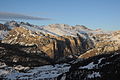
The Stevia (also Monte Stevia ) is a mountain of the Puez group in the Dolomites on the northern side of the valley of Val Gardena . The protected massif in the Puez-Geisler Nature Park is characterized by steep dolomite walls to the northwest, towers and gorges to the southeast to the Vallunga as well as an extensive summit plateau with alpine meadows, pastures and the Stevia hut . The highest point of the Stevia with 2555 m is on the northwest edge of the plateau. According to Castiglioni, the name Stevia means “distant pasture” in Ladin . North-east behind the Pizascharte ( 2489 m ) the mountain range continues to Montejela ( 2644 m ) and to Col dala Pieres ( 2747 m ).
In the direction of Vallunga, deep gorges separate the towers to the southeast. The first tower, Steviola ( 2083 m ), is separated from the second, the La Porta tower ( 2206 m ), marked by a mountain window , by the Val d' Andrea gorge. A second gorge, Valaccia , sloping from the high plateau to the southeast , is accessible with a little effort and separates the Ciastel ( 2196 m ) from the La Porta tower. The Pisciodel valley with a small waterfall separates another unnamed tower ( 2226 m ); the next gorge is the Val di Ciavai . The last valley, already at the foot of the Col dala Pieres, is the Val Ntaiëda .
The plateau can be reached via the normal route from Wolkenstein in the south via the so-called Palota and the Silvesterscharte. Another ascent leads from the Regensburger Hut to the west below the Stevia to the summit area.

West face of the Stevia

The first Stevia tower, Steviola, towards the southeast, at the entrance to the Langental with the ruins of the Wolkenstein castle
Southeast towers from Vallunga
Stevia general view from the south


Web links
Individual evidence
- ↑ Julius Gallhuber (arr.): Dolomites. A guide through the valleys, towns and mountains of the entire Dolomites. III. Volume: Western Dolomites . Artaria, Vienna 1929, p. 106.
- ↑ a b Ettore Castiglioni: Odle Sella Marmolada . Club Alpino Italiano - Touring Club Italiano, Roma / Milano 1937, pp. 313-314.