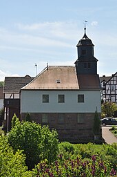
Elnrode strand
|
Elnrode strand
Jesberg parish
Coordinates: 50 ° 57 ′ 43 " N , 9 ° 9 ′ 43" E
|
|
|---|---|
| Height : | 273 m above sea level NHN |
| Area : | 3.71 km² |
| Residents : | 271 (Dec. 31, 2014) |
| Population density : | 73 inhabitants / km² |
| Incorporation : | December 31, 1971 |
| Postal code : | 34632 |
| Area code : | 06695 |
Elnrode-Strang is a district of the Jesberg community in the Schwalm-Eder district in Hesse ( Germany ). It is located in the southeast of the municipality on the upper reaches of the Schwalm tributary Schlierbach . Elnrode-Strang is made up of the village of Elnrode, which has around 230 inhabitants, and the smaller town of Strang, located just under 1 km to the northwest in the source area of the Schlierbach. State road 3145, which connects Jesberg with Schwalmstadt , runs through both places .
history
Elnrode was first mentioned in 1343 as Elinrade; later the spelling of the name changed to Elrode, Elm (e) rodt, Elnroda and finally Elnrode. In 1730 Karl Ludwig von Löwenstein-Schweinsberg sold his half of Elnrode to Prince Maximilian of Hesse ; In the same year he also bought the other half and received Elnrode as a Hessian fiefdom . After his death in 1753, Elnrode fell back to the Landgraviate of Hessen-Kassel as a failed fiefdom . Elnrode belonged to the Borken office and from 1791 to the newly created Jesberg office .
Strang was first mentioned in 1565 as ufm Strange , later names were de Strang and der Strangk . The village belonged to the Borken office, then from 1805 to the Jesberg office and later to the Jesberg judicial office. Ecclesiastically, Elrode mit Strang was parish off to the neighboring village of Schlierbach to the east from the 16th century before it became a subsidiary of Jesberg in 1820.
In 1916, the Treysa meteorite struck just under two kilometers south of Elnrode Strand .
In 1964, Elnrode and Strang merged to form the municipality of Elnrode-Strang. With the regional reform in Hesse , Elnrode-Strang became a district of the Jesberg community on December 31, 1971.
Attractions
- Hollow oak with a chest height of 7.34 m (2015).
literature
- Werner Ide: From Adorf to Zwesten. Local history pocket book for the Fritzlar-Homberg district. Bernecker Verlag, Melsungen 1972.
- Heinrich Reimer: Historical local lexicon for Kurhessen (= publications of the historical commission for Hessen and Waldeck. Vol. 14). Elwert, Marburg 1926, p. 461 (Unchanged reprint, ibid 1974, ISBN 3-7708-0510-0 ).
Individual evidence
- ↑ "Population figures " on the website of the Jesberg community ( memento from January 21, 2016 in the archive.today web archive ), accessed in January 2016.
- ^ "Elnrode, Schwalm-Eder district". Historical local lexicon for Hesse (as of May 21, 2014). In: Landesgeschichtliches Informationssystem Hessen (LAGIS). Hessian State Office for Historical Cultural Studies (HLGL), accessed on July 16, 2014 .
- ^ Federal Statistical Office (ed.): Historical municipality directory for the Federal Republic of Germany. Name, border and key number changes in municipalities, counties and administrative districts from May 27, 1970 to December 31, 1982 . W. Kohlhammer GmbH, Stuttgart and Mainz 1983, ISBN 3-17-003263-1 , p. 392 .
- ^ Entry in the directory of monumental oaks . Retrieved January 10, 2017
Web links
- Homepage of Elnrode-Strang
- Districts on the website of the community Jesberg
- "Elnrode-Strang, Schwalm-Eder-Kreis". Historical local dictionary for Hessen. In: Landesgeschichtliches Informationssystem Hessen (LAGIS).
- "Elnrode, Schwalm-Eder district". Historical local dictionary for Hessen. In: Landesgeschichtliches Informationssystem Hessen (LAGIS).
- "Strang, Schwalm-Eder district". Historical local dictionary for Hessen. In: Landesgeschichtliches Informationssystem Hessen (LAGIS).
