
Sund (Åland)
| coat of arms | map |
|---|---|

|

|
| Basic data | |
| State : |
|
| Landscape : | Åland |
| Administrative community : | Åland Country |
| Geographical location | 60 ° 15 ′ N , 20 ° 7 ′ E |
| Surface: | 184.13 km² |
| of which land area: | 108.07 km² |
| of which inland waterways: | 3.75 km² |
| of which sea area: | 72.31 km² |
| Residents : | 1,028 (Dec. 31, 2018) |
| Population density : | 9.5 inhabitants / km² |
| Municipality number : | 771 |
| Language (s) : | Swedish |
| Website : | www.sund.aland.fi |
Sund [ sʉnd ] is a municipality in the autonomous Finnish province ( Finnish : Lääni ) Åland . It lies in the east of Åland's main island, Fasta Åland , bordering the municipalities of Finström in the west and Saltvik in the north. Sund has 1028 inhabitants (as of December 31, 2018) and an area of 111.82 square kilometers. As in all of Åland, Swedish is the official language.
geography
Sund is one of the 27 official Finnish national landscapes that are considered to have particular symbolic value for Finnish history, culture and nature. In the case of Sund, this has to do with the historical importance of the municipality.
Attractions
Sund is the location of the medieval castle Kastelholm , which played an important role in the Scandinavian power struggles, especially in the 15th and 16th centuries. The castle is still one of Åland's great attractions. Russia built another military fortification in the 19th century in the form of the Bomarsund Fortress . The ruins of the fortress, which was destroyed in the Crimean War , can still be visited today.
Other sights in Sund are the medieval church, built around 1300, which is Åland's largest church, the Jan Karlsgården open-air museum and the Vita Björn prison museum .
economy
Sund's economy is now mainly driven by tourism , but traditional farming professions are still well represented. The local golf course is also one of the largest employers .
Economic characteristics Sunds (2007):
- Agriculture and forestry: 21.1%
- Construction and industry: 8.8%
- Public service, trade and transport: 69.9%
photos
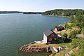
Archipelago near Haraldsby

Kastelholm Castle

The Church of Sund
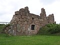
Ruins of the Bomarsund Fortress

Midsommarstång at Kastelholm Castle

Jan Karlsgården open-air museum


References
- ↑ Maanmittauslaitos (Finnish land surveying office): Suomen pinta-alat kunnittain January 1, 2010 (PDF; 199 kB)
- ↑ Statistical Office Finland: Table 11ra - Key figures on population by region, 1990-2018
- ↑ Brochure about Sund ( Memento of the original from October 1, 2008 in the Internet Archive ) Info: The archive link was inserted automatically and has not yet been checked. Please check the original and archive link according to the instructions and then remove this notice. (pdf)